Capitol District (Harrisburg, Pennsylvania)
Capitol District | |
|---|---|
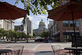
 Second and State Streets in front of the Capitol building | |
| Coordinates: 40°16′01″N 76°52′52″W / 40.267°N 76.881°W | |
| Country | |
| State | Pennsylvania |
| County | Dauphin County |
| City | Harrisburg |
| Area code(s) | 717 and 223 |
The Capitol District is a
Saint Patrick's Cathedral, St. Stephen's Episcopal Cathedral, State Museum of Pennsylvania, the historic Harrisburg Area YMCA
building, many beautiful houses, and several small bistros.
References
- ^ City of Harrisburg (2004). "Map of Capitol District" (PDF). harrisburgpa.gov/. Archived from the original (PDF) on September 27, 2007. Retrieved 2006-12-28.
