
Castle Dome (Zion National Park)
| Castle Dome | |
|---|---|
 Southeast aspect, from Zion Lodge | |
| Highest point | |
| Elevation | 7,054 ft (2,150 m)[1] |
| Prominence | 540 ft (160 m)[1] |
| Parent peak | Point 7180[1] |
| Isolation | 1.00 mi (1.61 km)[1] |
| Coordinates | 37°15′58″N 112°58′15″W / 37.2660965°N 112.9707089°W[2] |
| Geography | |
 Castle Dome Location in Utah  Castle Dome Castle Dome (the United States) | |
| Country | United States |
| State | |
Castle Dome is a 7,054-foot (2,150 m) elevation
U.S. Board on Geographic Names.[2]
Climate
Spring and fall are the most favorable seasons to visit Castle Dome. According to the
Cold semi-arid climate zone, which is defined by the coldest month having an average mean temperature below 32 °F (0 °C), and at least 50% of the total annual precipitation being received during the spring and summer. This desert climate receives less than 10 inches (250 millimeters) of annual rainfall, and snowfall is generally light during the winter.[4]
Gallery
-

-
-
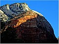
 Castle Dome from Zion Lodge
 -
 Castle Dome (left), The Spearhead (right)
 -
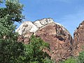
 Castle Dome from Zion Lodge
 -

.jpg)


.jpg)

See also
References
- ^ a b c d e "Castle Dome - 7,060' UT". listsofjohn.com. Retrieved 2020-09-10.
- ^ a b c U.S. Geological Survey Geographic Names Information System: Castle Dome
- ^ Castle Dome, Mountainproject.com
- ^ "Zion National Park, Utah, USA - Monthly weather forecast and Climate data". Weather Atlas. Archived from the original on January 27, 2019. Retrieved 31 August 2020.
External links
Wikimedia Commons has media related to Castle Dome (Zion National Park).
- Zion National Park National Park Service
- Weather forecast: Castle Dome
- Castle Dome rock climbing: Mountainproject.com
Places adjacent to Castle Dome (Zion National Park) | ||||||||||||||||
|---|---|---|---|---|---|---|---|---|---|---|---|---|---|---|---|---|
| ||||||||||||||||