
Castle Street, Oxford

Castle Street is a street in
St Ebbe's
area of southwest central Oxford.
"Castell Streate" can be found on a map of 1578 by
To the north there is a junction with
Westgate Shopping Centre
is to east at the northern end of the street.
Gallery
-
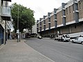 View up Castle Street pastWestgate Shopping Centre.
 -
 The Castle Tavern on Castle Street.


References
- ^ ISBN 0-333-39917-X.
External links
 Media related to Castle Street, Oxford at Wikimedia Commons
51°45′04″N 1°15′41″W / 51.7512°N 1.2613°W
This Oxfordshire location article is a stub. You can help Wikipedia by expanding it. |