
Castlepoint
Castlepoint
Rangiwhakaoma | |
|---|---|
Town | |
Gary Caffell | |
| • Wairarapa MP | Mike Butterick |
| • Ikaroa-Rāwhiti MP | Cushla Tangaere-Manuel |
| Area | |
| • Total | 0.81 km2 (0.31 sq mi) |
| Population (June 2023)[2] | |
| • Total | 60 |
| • Density | 74/km2 (190/sq mi) |
Castlepoint is a small beachside settlement on the Wairarapa coast of the Wellington Region of New Zealand.[3] It is home to a lighthouse which stands near the top of the northern end of a reef. The reef is about one kilometre long. At the southern end of the reef, there is an island known locally as "seagull island", due to its large population of seagulls. The southern side of Castle Rock is known as Christmas Bay. Castlepoint is approximately one hour's drive from Masterton.
Castlepoint was so named in 1770 by
Castle Rock is a landmark in Castlepoint and is 162m high.[4] It includes a walk through woods and over bridges and is approximately 45 minutes long.
Mataikona Sand Dunes are an area of large sand dunes approximately 30 minutes north of Castlepoint towards the Matakona River mouth.
Demographics
Castlepoint is described by Statistics New Zealand as a rural settlement and covers 0.81 km2 (0.31 sq mi).[1] It had an estimated population of 60 as of June 2023, with a population density of 74 people per km2.
| Year | Pop. | ±% p.a. |
|---|---|---|
| 2006 | 27 | — |
| 2013 | 42 | +6.52% |
| 2018 | 57 | +6.30% |
| Source: [6] | ||
.JPG)
Castlepoint had a population of 57 at the
Ethnicities were 94.7% European/Pākehā, and 5.3% Māori. People may identify with more than one ethnicity.
Although some people chose not to answer the census's question about religious affiliation, 68.4% had no religion, and 21.1% were Christian.
Of those at least 15 years old, 9 (17.6%) people had a bachelor's or higher degree, and 9 (17.6%) people had no formal qualifications. The median income was $30,000, compared with $31,800 nationally. The employment status of those at least 15 was that 27 (52.9%) people were employed full-time, and 6 (11.8%) were part-time.[6]
Castlepoint is part of the larger Whareama statistical area.[7]
Marae
The local Whakataki marae is affiliated with the
Annual horse races
Remote from other settlements Castlepoint's beach has been home since 1872 to an historic annual horse race meeting when "local station hands rode on farm hacks competing for bottles of rum and any stray coins".[10]
Lighthouse
Completed on 12 January 1913, it was one of the last manned lights built in New Zealand, but has been fully automated since 1988 and is now managed from a central control room in Wellington. [11] It is a popular tourist attraction for holidaymakers to the area, although it is not open to the public.
The lighthouse is built out of steel sheets riveted together. This is an unusual method of construction for a lighthouse and the only one so built in New Zealand.
At sea, the light can be seen 22 miles away, and was used by sailors coming from South America to establish a point of reference when making for Wellington Harbour.
A camera set up at the top of an outcrop looking down on the lighthouse gives people a chance to see it on live feed castlepointlighthouse.com.
In December 2017 the lighthouse was controversially installed with multi-colour LED up-lights which would light the exterior of the lighthouse all year round at a cost of $35,000. Many Wairarapa region residents feel the lights are 'gaudy' and a source of unnecessary light pollution.[1]
Gallery
-
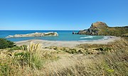 Deliverance Cove and Castle Rock
 -
 Castlepoint Lighthouse from the beach at Castlepoint
 -
 Castlepoint Lighthouse looking towards Castle Rock
 -
 New Zealand fur sealon a rock at Castle point


.jpg)
References
- ^ a b "ArcGIS Web Application". statsnz.maps.arcgis.com. Retrieved 25 June 2023.
- ^ "Subnational population estimates (RC, SA2), by age and sex, at 30 June 1996-2023 (2023 boundaries)". Statistics New Zealand. Retrieved 25 October 2023. (regional councils); "Subnational population estimates (TA, SA2), by age and sex, at 30 June 1996-2023 (2023 boundaries)". Statistics New Zealand. Retrieved 25 October 2023. (territorial authorities); "Subnational population estimates (urban rural), by age and sex, at 30 June 1996-2023 (2023 boundaries)". Statistics New Zealand. Retrieved 25 October 2023. (urban areas)
- ^ "Castlepoint Travel Guide". www.jasons.co.nz. Jasons Travel Media. Archived from the original on 13 February 2020. Retrieved 28 February 2021.
- ^ a b "Castlepoint Scenic Reserve". Department of Conservation. Retrieved 18 November 2012.
- ^ "Castlepoint, Coastal Station and Settlement". Hedleys Books. Retrieved 18 November 2012.
- ^ a b "Statistical area 1 dataset for 2018 Census". Statistics New Zealand. March 2020. 7022198.
- ^ 2018 Census place summary: Whareama
- ^ "Te Kāhui Māngai directory". tkm.govt.nz. Te Puni Kōkiri.
- ^ "Māori Maps". maorimaps.com. Te Potiki National Trust.
- ^ "Castlepoint Beach races return". Fairfax Media. 11 March 2012. Retrieved 2 August 2016.
- ^ Castle Point Lighthouse Profile Archived 17 November 2015 at the Wayback Machine (from the Maritime New Zealand website)
| International | |
|---|---|
| National | |