
Château fort de Lourdes


The château fort de Lourdes (
History
Besieged in 778 by Charlemagne, it became the residence of the Counts of Bigorre in the 11th and 12th centuries. In the 13th century, it passed into the possession of the Counts of Champagne, part of the kingdom of Navarre before coming under the crown of France under Philippe le Bel. It was ceded to the English by the Treaty of Brétigny in 1360, before returning to France at the start of the 15th century after two sieges. In the 17th century, the castle became a royal prison, and then a state prison after the French Revolution. It continued in this role until the start of the 20th century, when it became the Pyrenean Museum (Musée Pyrénéen) (1921) which it remains
Description
The castle's origins go back to Roman times.[3] Various remains from this era (fragments of sculpture, votive offerings, wall foundations) were brought to light by military engineering work in the 19th century, which however destructed the greater part of the ancient walls. The finds are exhibited on the site.
Today, the oldest remains date from the 11th and 12th centuries and consist of the foundations of the present fortifications. The castle was reinforced in the 13th and 14th centuries (construction of the
The Notre-Dame-du-Château chapel houses the furniture of the former parish church of Saint-Pierre de Lourdes, destroyed in 1904. The present chapel is constructed with recycled material from Saint-Pierre de Lourdes.

Photographic gallery
-
 Castle in 1843, by Eugène de Malbos
 -
 View from the west
 -
 The keep
 -
 Illuminated at night
 -
 Castle (east face with the clock)
 -
 With the Pyrenees in the background
 -
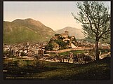 The castle standing over the town (photo taken between 1890 and 1900)
 -
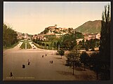 View from the terrace of Sanctuary of Our Lady of Lourdes
 -
 Castle and river
_-_Fonds_Ancely_-_B315556101_A_MALBOS_2_005.jpg)


See also
References and sources
- ^ Mrs. Amy (Ewing) Oakley (1923). Hill-Towns of the Pyrenees. Century Company. p. 304.
- ^ Base Mérimée: PA00135708, Ministère français de la Culture. (in French) Château fort
- ISBN 9781804692172.
- ^ "A thousand years of history - Château fort Musée Pyrénéen". chateaufort-lourdes.fr (in French). Retrieved 22 December 2023.
- Lourdes de la Préhistoire à nos jours, Musée Pyrénéen, 1987.
External links
- Chateau Fort - Musée Pyrénéen—Official site
| International | |
|---|---|
| National | |
| Geographic | |