
Cherbourg Harbour
49°39′33″N 1°36′42″W / 49.659072°N 1.611729°W
You can help expand this article with text translated from the corresponding article in French. (May 2011) Click [show] for important translation instructions.
|

Cherbourg Harbour (French: rade de Cherbourg; literally, the "roadstead of Cherbourg") is a harbour situated at the northern end of the Cotentin Peninsula, on the English Channel coastline, in Normandy, northwestern France. With a surface area of 1,500 hectares, it is the second largest artificial harbour in the world, after the 4,500 hectare Ras Laffan Harbour in Qatar. As well as Cherbourg Naval Base, it has been used for mercantile shipping.
It was begun in 1783, with its central harbour breakwater completed in 1853 – this was 3.64 km long, an average of 100 m wide at its base and an average of 12 m wide at its top, and sited 4 km from the coast. Three forts were added to its central wall in 1860. This and the two other breakwaters stretch for more than 6 km. The eastern opening into the harbour is 950 m wide and the western one 2.3 km wide. The harbour's maximum depth is 13 m at low tide.
History
Cherbourg had been a strategic stronghold for several centuries - its castle was first built in the 5th century to protect the whole width of the

The long-planned fortification of the town was finally set in motion by
Construction began in 1783 and was completed in 70 years, by three architects -
In 1802, intending to make Cherbourg one of his main military ports in preparation for his

Works on the central wall were again interrupted between 1813 and 1832 and were only finally completed in 1853 under
Forts
Fort du Homet
Fort de l'île Pelée
Fort Chavagnac
-
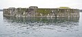 Fort de Chavagnac

Fort de l'Est
-
 Fort de l'Est, destroyed during the Second World War

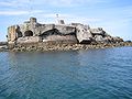
Fort de l'Ouest
-
 Fort de l'Ouest

Central fort
-
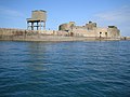 Fort Central

Fort de Querqueville
-
 Entrance to the Fort de Querqueville
 -
 The casemates of Fort de Querqueville


Fort des Flamands
Gallery
-
 Western wall of the outer harbour
 -
 View of the harbour from the cemetery at Querqueville
 -
 View of the harbour from the cemetery at Querqueville


Citations
General bibliography
- (In French) Bazan, "Quels sont les hommes qui ont exercé le plus d'influence sur la création d'un arsenal maritime à Cherbourg et en particulier quelle part doit être attribuée à Vauban dans les projets relatifs à la fermeture de la rade", extract from Séances du congrès scientifique de France, tenu à Cherbourg en septembre 1860. Cherbourg : Auguste Mouchel, 1860. 16 pages
- (In French) Yves Murie, La Digue qui a fait Cherbourg. Cherbourg, Isoète, 2007 - ISBN 978-2-913920-59-0
External links
- (In French) « Les forts de la rade de Cherbourg ( 50 ) », Les Chemins de la mémoire,
- (In French) « Les forts de la rade de Cherbourg », Netmarine
- (In French) Forts de la grande rade de Cherbourg
- (In French) La grande rade, ville de Cherbourg-Octeville
- (In French) Situation de la Passe Cabart-Danneville[permanent dead link]