
Chosen Hill, Gloucestershire
| Chosen Hill | |
|---|---|
 Footpath on Chosen Hill, Churchdown | |
 Chosen Hill shown within Gloucestershire | |
| Type | Gloucestershire Wildlife Trust nature reserve |
| Location | between Gloucester and Cheltenham |
| Coordinates | 51°52′1.93″N 2°10′19.39″W / 51.8672028°N 2.1720528°W |
| Area | 28.5 acres (11.5 ha) |
| Created | 1990 |
| Operated by | Gloucestershire Wildlife Trust Severn Trent plc |
| Status | Open all year |
Chosen Hill (grid reference SO882187) (or Churchdown Hill) rises above Churchdown[1] in Gloucestershire, England, and is the site of a 11.5-hectare (28-acre) nature reserve.[2]
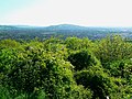
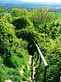
The hill commands good views over the scarp and the Severn Vale and there is a network of paths for walkers. One such path is 'coffin way' from St Bartholomew's Church at the top of the hill towards Hucclecote.[2]
Covered reservoirs were constructed on the Hill in the 1940s and 1950s. There is an archaeological site - an Iron Age fort known as Churchdown Hill Camp - below the main reservoir.[2][3]
Geologically, it is on one of
Nature reserves
The Hill is encircled by four nature reserves, considered and managed as one reserve, by the Woodland Trust[4][5] and also by Gloucestershire Wildlife Trust under agreement with Severn Trent plc since 1990.[2]
Trees
The largest conifers were planted some 120 years ago. Recent planting dates from the 1940s. The large trees include
The ancient woodland area includes
Plants
The reserve is known for its spring flowering of
The grassland area is now unimproved and
There is a limestone-loving range of plants at the top of the slope which include
Birds
Breeding birds recorded are
Conservation
Over the years, there has been felling of some of the conifers and dense areas of
Cultural influence
Chosen Hill was a favourite haunt of the early twentieth-century composers Ivor Gurney and Herbert Howells - it was the direct inspiration for Howells' Piano Quartet in A minor and his 'Chosen Tune' (the latter dedicated to his fiancée who lived at Churchdown).[6]
In 2010, the BBC reported that Willard Wigan, famed for his microscopic art, had sculpted a model of Chosen Hill's St Bartholomew's church on a grain of sand that he had taken from its churchyard. He had done so in response to a challenge from his girlfriend, who described the result as "absolutely fantastic". Despite positive feedback, Wigan expressed dissatisfaction with the work, saying "As small as what you've seen, it's not the best of me yet, I'm taking it even smaller because I'm not satisfied with my work right now, it's too big."[8]
Residents
Although the hill is primarily a nature and recreation area, it is not free of residentsː the residential area of the village of Churchdown stretches with a so-called better residential area on the northern slope in the course of the access road to the summit up to about 95 meters above sea level . Chosen Hill Cottage, an inhabited house, is located on the summit plateau itself, about 50 meters east of the summit. To the west and south are a few houses, the so-called Oystershell Cottages (Buscombe Noake) up to an altitude of 95 meters above sea level; one of these cottages was in earlier times a "tea garden" and a favorite meeting place for the residents of Churchdown and Hucclecotes.
Publications
- Kelham, A, Sanderson, J, Doe, J, Edgeley-Smith, M, et al., 1979, 1990, 2002 editions, 'Nature Reserves of the Gloucestershire Trust for Nature Conservation/Gloucestershire Wildlife Trust'
- 'Nature Reserve Guide – discover the wild Gloucestershire on your doorstep' – 50th Anniversary, January 2011, Gloucestershire Wildlife Trust
References
- ^ a b 'Nature Reserve Guide – discover the wild Gloucestershire on your doorstep' – 50th Anniversary, January 2011, Gloucestershire Wildlife Trust
- ^ a b c d e f g h i j k l Kelham, A, Sanderson, J, Doe, J, Edgeley-Smith, M, et al., 1979, 1990, 2002 editions, 'Nature Reserves of the Gloucestershire Trust for Nature Conservation/Gloucestershire Wildlife Trust'
- ^ The Megalithic Portal and Megalith Map. "Churchdown Hill Camp". Megalithic.co.uk. Retrieved 9 February 2014.
- ^ "Woodland Trust online information on Churchdown Hill reserve". Woodlandtrust.org.uk. Retrieved 9 February 2014.
- ^ The individual reserves are called: Churchdown Hill East, Churchdown Hill West, The Pines, and Churchdown Hill Extension (Tinkers Hill)
- ISBN 978-1-84609-722-5.
- ISBN 978-085115-823-5.
- ^ "Sculptor carves Gloucestershire church in sand grain". BBC News. 26 March 2010. Retrieved 5 March 2016.
External links
-
 Trig point on Chosen Hill (Churchdown Hill)
 -
 View to Chosen Hill, Churchdown
 -
 View from top of Chosen Hill
 -
 View from top of Chosen Hill to Robinswood Hill
 -
 Foothpath on Chosen Hill to south-west
 -
 Foothpath on Chosen Hill
 -
 Footpath on Chosen Hill to north-west
 -
 Footpath to Chosen Hill
 -
 Reservoir on Chosen Hill, Churchdown
 -
 St Bartholomew's Church, Chosen Hill
 -
 St Bartholomew's Church, Chosen Hill


