
Civil Lines, Karachi
Civil Lines
شہری لَکیریں | |
|---|---|
NA-247 (Karachi South-II) | |
| • National Assembly Member | Aftab Siddiqui (PTI) |
Civil Lines (
History
Civil Lines formed part of the "New Town" established during the colonial era, and developed shortly after the British gained control of Karachi from the Talpurs in 1839.[2] It was built to the east of the densely-populated "Native Town" (made up of Mithadar and Jodia Bazaar), and was specifically designed to be spacious area, in contrast to the densely populated Native Town. It was primarily residential, and was where much of the British officials and local elite resided in Karachi during the colonial era.[1] To the north of Civil Lines was the European commercial district of Saddar, and to the south the affluent seaside municipality of Clifton.
Following independence, the residential patterns established by the British continued, with Karachi's wealthy residents establishing affluent neighbourhoods in the southern and eastern parts of the city,[3] with poorer areas in the north and west.
There are several ethnic groups including
Main areas
- PIDC
- Bagh-i-Quaid-i-Azam
- Commissioner House
- Chief Secretary House
- Chief Minister House
- Governor House
- Sindh Secretariat
- Shafi Court
- Hotel Metropolis
- Pearl Continental Hotel
- Move n Pick
- Marriot Hotel
- Hijrat Colony
- Court of Law
- Dehli Colony
- Panjab Colony
- Hashmi Colony
- Kashmir Mujahid colony
- Frere Hall
- Artlary Madan
Gallery
-
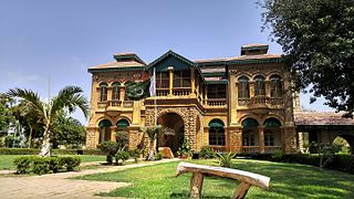 Quaid-e-Azam House is the former home of Pakistan's founder, Muhammad Ali Jinnah
 -
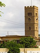 Holy Trinity Cathedral
 -
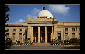 Victoria Museum building
 -
 Edward House - one of several colonial-era commercial centres
 -
 Victoria Mansion commercial building


.jpg)


References
- ^ ISBN 978-0-19-935444-3.
- ISBN 978-81-204-1277-4.
- ISBN 978-0-7425-5597-6.
External links
This geography of Karachi-related article is a stub. You can help Wikipedia by expanding it. |