
Clava cairns of Aviemore
There are three Clava cairns in or near the Scottish Highland town of Aviemore. All three were described by Caleb George Cash, an honorary fellow of the Royal Scottish Geographical Society, in 1906.
Delfour stone circle
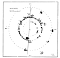
The stone circle is 4 miles SW of Aviemore railway station, and 2 miles NNE of Kincraig railway station, and in 1906 was located near a cottage. Its condition, as described by Cash in 1906, is ruinous; it could hardly be recognized as anything other than "a heap of stones cleared by the farmer from his fields". One stone of "striking appearance" is still standing. The middle circle of ca. 60 feet in diameter seems to have been used for the purpose of field clearing, with stones from the outer circles having been deposited there. The one solitary stone from what may have been an outer circle stands about 22 feet SW from the middle circle; it is a quartzite slab, 9'6" high, 5'6" wide, and 1'6" thick. Since it's tapered toward the top, it appears to Cash as a "cloaked human figure".[1]
There is an outer kerb (58 ft in diameter) and an inner ring, made of smaller stones. There was a bank of small stones just outside the kerb, which was part of the design; stones from the field have been thrown onto that bank.[2]
Gallery
-
 Drawing by Cash, 1906

Aviemore stone circle
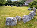
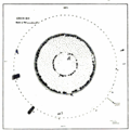
The cairn consists of three stone circles, or remnants thereof. The outer one, of detached megaliths, is ca. 75 ft in diameter.[1] The second circle is of graded kerbstone sets closely,[3] with a diameter of ca. 42 feet, and the inner circle is ca. 26 feet.[1] The cairn is mostly gone and only three or four slabs are left.[3]
In 1877 there were still seven stones standing in the centre; when Aubrey Burl detailed the cairn in 2005, there were only five left, one of which has fallen. The tallest is 1.5 m high.The cairn is currently in the middle of a housing estate.[3]
Gallery
-
 1906 drawing by Cash
 -
 Aviemore stone circle
 -
 Aviemore stone circle


Grenish stone circle
The Grenish circle is a little over 2 miles E.N.E. of the Aviemore railway station, some 350 yards east of the road, in an area of uneven moorland
Gallery
-
 1906 drawing by Cash

See also
References
- ^ a b c d e Cash, Caleb George (1906). "Stone Circles near Aviemore". The Cairngorm Club Journal. 5 (27): 151–63.
- ^ "Delfour". Canmore. Retrieved 9 April 2022.
- ^ ISBN 9780300114065.
- ^ On the history of forestation in the Spey Valley, see Fenton, E. Wyllie (1935). "The Transition From Woodland and Moorland to Grassland in the Spey Valley and Elsewhere". Journal of Ecology. 23 (1): 56–68.
External links
- Highland Historic Environment Records: