
Clayton, Michigan
Clayton, Michigan | ||
|---|---|---|
FIPS code 26-16280[3] | | |
| GNIS feature ID | 0623395[4] | |
| Website | Official website | |
Clayton is a village in
History
The community was first settled in 1836 and named East Dover due to its location in eastern Dover Township. A post office began operating in East Dover on March 8, 1837 with Levi Soper serving as the first postmaster. Rueben Bird platted the community in 1843, and he had the post office name changed to Clayton on July 17, 1849 after his friend Reverend Clayton from New York. Clayton was incorporated as a village in 1870.[5]
Geography
According to the U.S. Census Bureau, the village has a total area of 0.71 square miles (1.84 km2), all land.[6]
Major highways
 M-34 (West Carleton Road) runs east–west near the southern boundary of the village.
 M-156 (Morey Highway) has its northern terminus at M-34.
Demographics
| Census | Pop. | Note | %± |
|---|---|---|---|
| 1880 | 368 | — | |
| 1900 | 370 | — | |
| 1910 | 372 | 0.5% | |
| 1920 | 306 | −17.7% | |
| 1930 | 372 | 21.6% | |
| 1940 | 375 | 0.8% | |
| 1950 | 467 | 24.5% | |
| 1960 | 470 | 0.6% | |
| 1970 | 505 | 7.4% | |
| 1980 | 396 | −21.6% | |
| 1990 | 384 | −3.0% | |
| 2000 | 326 | −15.1% | |
| 2010 | 344 | 5.5% | |
| 2020 | 311 | −9.6% | |
| U.S. Decennial Census[7] | |||
2010 census
As of the
There were 118 households, of which 40.7% had children under the age of 18 living with them, 55.1% were married couples living together, 13.6% had a female householder with no husband present, 7.6% had a male householder with no wife present, and 23.7% were non-families. 17.8% of all households were made up of individuals, and 5.1% had someone living alone who was 65 years of age or older. The average household size was 2.92 and the average family size was 3.34.
The median age in the village was 31.5 years. 30.5% of residents were under the age of 18; 8.5% were between the ages of 18 and 24; 31.4% were from 25 to 44; 17.7% were from 45 to 64; and 11.9% were 65 years of age or older. The gender makeup of the village was 52.0% male and 48.0% female.
2000 census
As of the
There were 113 households, out of which 34.5% had children under the age of 18 living with them, 59.3% were married couples living together, 8.0% had a female householder with no husband present, and 25.7% were non-families. 19.5% of all households were made up of individuals, and 8.0% had someone living alone who was 65 years of age or older. The average household size was 2.88 and the average family size was 3.31.
In the village, the population was spread out, with 29.1% under the age of 18, 11.0% from 18 to 24, 26.4% from 25 to 44, 23.6% from 45 to 64, and 9.8% who were 65 years of age or older. The median age was 31 years. For every 100 females, there were 102.5 males. For every 100 females age 18 and over, there were 108.1 males.
The median income for a household in the village was $41,875, and the median income for a family was $46,172. Males had a median income of $30,000 versus $20,000 for females. The
Education
The village of Clayton is served by Hudson Area Schools to the west in the city of Hudson.[9]
Images
-
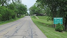 Signage along Morey Highway
 -
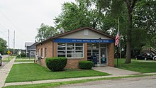 U.S. Post Office in Clayton
 -
 Clayton Town Hall and Library


References
- ^ Lenawee County (2022). "Lenawee County, Michigan Government Directory". p. 37. Retrieved June 15, 2022.
- ^ "2020 U.S. Gazetteer Files". United States Census Bureau. Retrieved May 21, 2022.
- ^ a b "U.S. Census website". United States Census Bureau. Retrieved January 31, 2008.
- ^ "US Board on Geographic Names". United States Geological Survey. October 25, 2007. Retrieved January 31, 2008.
- ISBN 978-0-8143-1838-6.
- ^ "US Gazetteer files 2010". United States Census Bureau. Archived from the original on January 25, 2012. Retrieved November 25, 2012.
- ^ "Census of Population and Housing". Census.gov. Retrieved June 4, 2015.
- ^ "U.S. Census website". United States Census Bureau. Retrieved November 25, 2012.
- ^ Michigan Geographic Framework (November 15, 2013). "Lenawee County School Districts" (PDF). Archived (PDF) from the original on August 20, 2014. Retrieved June 18, 2022.
Municipalities and communities of Lenawee County, Michigan, United States | ||
|---|---|---|
| Cities |  | |
| Villages | ||
| Charter townships | ||
| Civil townships | ||
| CDPs | ||
| Other communities |
| |
| Footnotes | ‡This populated place also has portions in an adjacent county or counties | |
| ||
| International | |
|---|---|
| National | |