
Col des Mosses
| Col des Mosses | ||
|---|---|---|
Elevation 1,445 m (4,741 ft)[1]< | | |
| Traversed by | Road | |
| Location | Vaud, Switzerland | |
| Range | Alps | |
| Coordinates | 46°24′11.46″N 07°06′8.34″E / 46.4031833°N 7.1023167°E | |
 Col des Mosses Location in Switzerland | ||
Col des Mosses (elevation 1445 m) is a
Road and public transports
The pass is traversed by a major road between Aigle and Château-d'Œx. From Aigle, the road ascends 1,028 metres (3,373 ft) over a distance of 18.8 kilometres (11.7 mi), whilst from Château-d'Œx it ascends 521 metres (1,709 ft) over 14 kilometres (8.7 mi). The road is normally kept open throughout the year.
Sports
The Col des Mosses is also on the Alpine Pass Route hiking trail, and is a winter sports centre.[5] The Tour de France has crossed the Col des Mosses on five occasions (in 1949, 1997, 2000, 2009 and 2016). The Tour de Romandie has crossed the col three times (in 2008, 2012 and 2013), and the Tour de Suisse just once (in 2010).[citation needed]
-
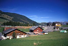 The summit of the pass in summer
 -
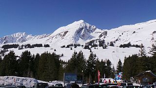 The pass in winter

.jpg)
See also
- List of highest paved roads in Europe
- List of mountain passes
- List of the highest Swiss passes
- Lac Lioson
References
- ^ a b c map.geo.admin.ch (Map). Swiss Confederation. Retrieved 21 July 2016.
- ^ "Col des Mosses". www.dangerousroads.org. Archived from the original on 22 July 2016. Retrieved 22 July 2016.
- ^ "Col des Mosses" (in French). Canton de Vaud. Archived from the original on 26 July 2016. Retrieved 26 July 2016.
- ^ "Le Sépey–Col-des-Mosses–Château-d'Oex" (PDF). Bundesamt für Verkehr. Retrieved 26 July 2016.
- ISBN 978 1 85284 600 8.
External links
This Vaud location article is a stub. You can help Wikipedia by expanding it. |