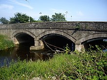
Cowie Bridge

Cowie Bridge is a
, Scotland.Historically, the area in the vicinity of the Cowie Bridge site has been an old fishing village known as
medieval route crossing the coastal Grampian Mountains northerly by way of Muchalls Castle and Gillybrands.[3]
See also
- Cowie Castle
- Chapel of St. Mary and St. Nathalan
References
- ^ Archibald Watt, Highways and Byways around Kincardineshire, Stonehaven Heritage Society (1985)
- ^ New Route Will Cut Chaos, Mearns Leader, 19 March 2007[permanent dead link]
- ^ C.Michael Hogan, Causey Mounth, Megalithic Portal, ed. by A. Burnham, 3 November 2007
56°58′04″N 2°12′33″W / 56.9678°N 2.2093°W
