
Dastakert
Dastakert
Դաստակերտ | |
|---|---|
UTC+4 (AMT ) |
Dastakert (Armenian: Դաստակերտ) is a village in the Sisian Municipality of the Syunik Province in Armenia. It is located 225 km south of the capital Yerevan and 115 km northwest of the provincial centre Kapan. According to the 2016 official estimate, the current population of Dastakert is around 300.
Etymology
Founded as a summer resort for the monks of the nearby
History
Middle Ages
Dastakert was first mentioned by the historian
Between the 12th and 15th centuries, Syunik along with the rest of the historic territories of Armenia suffered from the Seljuk, Mongol,
Iranian and Russian rule
At the beginning of the 16th century, Syunik became part of the
In 1813, Syunik (including Dastakert) became part of the
20th century and beyond


With the establishment of the
During the Soviet period, the Dastakert copper and molybdenum mines were found in 1945. With the establishment of the Dastakert branch of the Zangezur copper-molybdenum plant in 1951, Dastakert was granted the status of an urban-type settlement within the Sisian raion. In 1968 – the period of the Soviet heydays – Dastakert had over 4,000 residents.
However, following the closure of the copper-molybdenum combine in 1975, the population drastically declined. Following the independence of Armenia, Dastakert retained its status as an urban settlement until the administrative reforms of November 2017, when it was turned into a rural settlement as part of the Sisian community.
According to the 2011 census the population of Dastakert was 323, up from 287 reported during the 2001 census.[6] As of 2016, around 300 residents live in Dastakert, most of them being Armenian refugees from Azerbaijan.
Geography
Historically, the area of Dastakert was part of Tsghuk canton (Armenian: Ծղուկք գավառ Tsghukk gavar), at the heart of the ancient
Dastakert is situated on the slopes of Mount Ayri of the Zangezur Range, near the roots of the Ayri River (a tributary of the Sisian River). At an average height of 2,050 meters above sea level, Dastakert is regarded as a mountainous settlement.
Demographics
Population
Dastakert is one of the smallest settlements in Armenia. It was one of the smallest urban settlements in the world in terms of population. The population of Dastakert grew significantly during the 1950s and 1960s after the opening of the Dastakert branch of the copper-molybdenum plant, exceeding 4,000 residents. Since the mid-1970s, the population has gradually declined with the closure of the plant. Currently, the population of Dastakert is around 300 who are entirely Armenians, most of them refugees from Azerbaijan. Between two and three children are born in Dastakert every year.[8]
Population timeline of Dastakert since 1908:
| Year | 1908 | 1922 | 1959 | 1976 | 2001 | 2011 | 2016 |
|---|---|---|---|---|---|---|---|
| Population | 555 | 358 | 2,405 | 3,655 | 287 | 323 | 300 |
Healthcare in Dastakert is provided by the nearby Sisian Medical Center.[9]
Municipal administration
Dastakert was Armenia's smallest urban community in terms of both population and area until November 2017 when it became a rural settlement.
Culture
The cultural heritage of Dastakert includes a medieval settlement located 2 km northwest of Dastakert, a medieval cemetery in the north of the city, and a khachkar dating back to 1320. There is a lithographic inscription 2 km north of Dastakert on a rock known by the locals as Vardapet, dating back to the 14th century.
Dastakert is currently home to a public education high school, a cultural centre, a music school, as well as a public library run by the municipality.[10]
Transportation
Dastakert can be only reached by the regional H-44 road that connects the village with Sisian in the north, near the Tolors reservoir.
Economy
In 1995, the government of independent Armenia reaffirmed the status of Dastakert as an urban settlement within the Syunik Province, until November 2017 when the settlement was stripped of its status and became a village. The economy of the village is one of the poorest in Armenia.[11]
Most of the village's residents are involved in agriculture. However, only 8% of them have permanent jobs, mainly in the post office, the municipal administration and the school. In recent years, a branch of the Zangezur Copper and Molybdenum Combine with its ore-dressing mill was opened on the basis of Dastakert's old Soviet copper-molybdenum plant.
Gallery
-
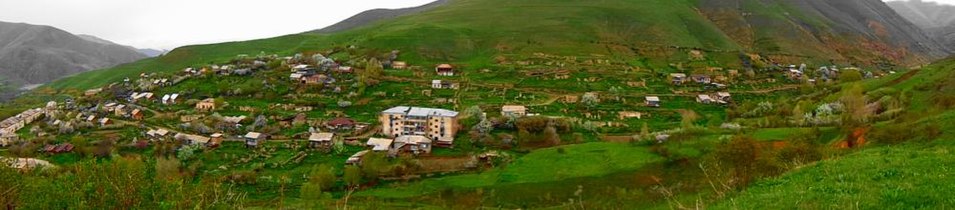 Panorama of Dastakert

See also
- Syunik (historic province)
- Zangezur Copper and Molybdenum Combine
References
- ^ "Syunik regional e-Governance System" (in Armenian). Syunik Province provincial government. Click on link entitled "Համայնքներ" (community) and search for the place by Armenian name.
- ^ Statistical Committee of Armenia. "The results of the 2011 Population Census of the Republic of Armenia" (PDF).
- ^ Դաստակերտ
- ^ "Syunik: Dastakert". Archived from the original on 2014-04-28.
- ^ Капан (in Russian). abp.am. Archived from the original on May 5, 2010. Retrieved August 28, 2009.
- ^ Report of the results of the 2001 Armenian Census, Statistical Committee of Armenia
- ^ About Dastakert
- ^ "Hetq online: Society- Bread is Scarce in Dastakerd". Archived from the original on 2010-05-16. Retrieved 2010-05-06.
- ^ Dastakert community of Syunik
- ^ About the community of Dastakert
- ^ Dastakert. The smallest town in the world
