
Khot, Armenia
Khot
Խոտ | |
|---|---|
UTC+4 (AMT) | |
| Khot, Armenia at GEOnet Names Server |
Khot (Armenian: Խոտ) is a village in the Tatev Municipality of the Syunik Province in Armenia. It is located on the left side of the Vorotan river, 67 kilometers from the regional center of Kapan.[3] On the cliffs below Khot are the ruins of Hin Khot (Old Khot), the previous location of the village until the 1970s.
The village was included under the same name in the Zangezur uezd within the Elizavetpol Governorate of Russian Empire.
During the Soviet years, Khot was a part of the Zangezur province of the Armenian SSR, and from 1930, it was part of the Goris region. Since 1995, the village has been part of the Syunik province of RA, since 2015 it is part of the enlarged Tatev Municipality.
Toponymy
The village was previously known as Khotavan, from Khot + avan (town).[4] The name of the settlement is directly from the Armenian word Khot meaning herbage/grass. According to Heinrich Hübschmann, this is in reference to the rich gardens surrounding old Khot named Khotaget, Khot (grass) + get (river).[5]
History
Khot was first mentioned as a town within the Haband gavar (county) of the

During the Soviet period, Khot was located in the Goris region of the Armenian SSR. A new settlement was built on a plateau outside of the old city, it contained an 8-year school, medical center, newly planned streets, a cinema, and a library.[6] The old city of Khot was abandoned in the 1960s-70s when its inhabitants were moved to higher ground closer to the main road and utility on flatter land.[10] Ancient cave-dwellings have been preserved in the village and its surroundings.[7]
Demographics
Population
The
| Year | Pop. | ±% p.a. | ||
|---|---|---|---|---|
| 1831 | 173 | — | ||
| 1873 | 739 | +3.52% | ||
| 1897 | 938 | +1.00% | ||
| 1926 | 788 | −0.60% | ||
| 1939 | 675 | −1.18% | ||
| 1959 | 600 | −0.59% | ||
| 1970 | 739 | +1.91% | ||
| 1979 | 830 | +1.30% | ||
| 1989 | 855 | +0.30% | ||
| 2001 | 890 | +0.33% | ||
| 2004 | 961 | +2.59% | ||
| ||||
| Source: [3][4] | ||||
Gallery
-
 Mrgadzori khach church
 -
 Ruins of Hin Khot
 -
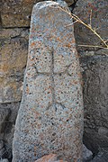 Khatchkar from 1409 in Khot
 -
 Hin Khot
 -

-
 17th-18th century khachkar in Khot
 -
 Scenery
 -
 WWII monument in Khot
 -
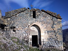 Hin Khot Church
 -


References
- ^ "Syunik regional e-Governance System" (in Armenian). Syunik Province provincial government. Click on link entitled "Համայնքներ" (community) and search for the place by Armenian name.
- ^ Statistical Committee of Armenia. "The results of the 2011 Population Census of the Republic of Armenia" (PDF).
- ^ a b Cadastral Committee of Armenia 2008, pp. 97–98.
- ^ a b c Hakobyan, Melik-Bakhshyan & Barseghyan 1988, p. 786.
- ^ Hübschmann 1904, p. 432.
- ^ a b c Hakobyan, Melik-Bakhshyan & Barseghyan 1988, p. 787.
- ^ a b Ambartsumian 1979, p. 81.
- ^ Kiesling & Kojian 2005, p. 55.
- ^ a b Yermolov 1866, p. 141.
- ^ Allen & Holding 2023, p. 352.
- ^ "Marzes of Armenia and Yerevan City in Figures, 2010" (PDF). Statistical Committee of Armenia.
- ^ Report of the results of the 2001 Armenian Census, Statistical Committee of Armenia
- ^ Кавказский календарь на 1912 год [Caucasian calendar for 1912] (in Russian) (67th ed.). Tiflis: Tipografiya kantselyarii Ye.I.V. na Kavkaze, kazenny dom. 1912. Archived from the original on 11 December 2021. p. 218
- ^ Кавказский календарь на 1915 год [Caucasian calendar for 1915] (in Russian) (70th ed.). Tiflis: Tipografiya kantselyarii Ye.I.V. na Kavkaze, kazenny dom. 1915. Archived from the original on 4 November 2021. p. 199
Bibliography
- Allen, Tom; Holding, Deidre (2023). Armenia: with Nagorno-Karabakh. Bradt Travel Guides (6 ed.). Connecticut: ISBN 9781784779436.
- OCLC 22420067.
- Cadastral Committee of Armenia (2008). Dictionary of settlements of the Republic of Armenia (PDF). Yerevan: Center for Geodesy and Cartography" SNCO. Archived from the original (PDF) on 12 September 2014.
- OCLC 247335945.
- ISBN 9783111258621.
- ISBN 9994101218.
- Yermolov, Aleksey (1866). Opisaniye Karabakhskoy provincii sostavlennoye v 1823 g po rasporyazheniyu glavnoupravlyayushego v Gruzii Yermolova deystvitelnim statskim sovetnikom Mogilevskim i polkovnikom Yermolovim 2-m [Description of the Karabakh province prepared in 1823 according to the order of the governor in Georgia Yermolov by state advisor Mogilevsky and colonel Yermolov 2nd] (in Russian). Tbilisi. p. 141.)
{{cite book}}: CS1 maint: location missing publisher (link
