
David City, Nebraska
David City, Nebraska | ||
|---|---|---|
FIPS code 31-12315 | | |
| GNIS feature ID | 837956[2] | |
| Website | davidcityne.com | |
David City is a city in
Name
Geography
According to the United States Census Bureau, the city has a total area of 2.07 square miles (5.36 km2), of which 2.06 square miles (5.34 km2) is land and 0.01 square miles (0.03 km2) is water.[9]
Climate
| Climate data for David City 4E, Nebraska (1991–2020 normals, extremes 1897–present) | |||||||||||||
|---|---|---|---|---|---|---|---|---|---|---|---|---|---|
| Month | Jan | Feb | Mar | Apr | May | Jun | Jul | Aug | Sep | Oct | Nov | Dec | Year |
| Record high °F (°C) | 71 (22) |
79 (26) |
89 (32) |
96 (36) |
105 (41) |
106 (41) |
114 (46) |
111 (44) |
104 (40) |
96 (36) |
85 (29) |
76 (24) |
114 (46) |
| Mean daily maximum °F (°C) | 31.1 (−0.5) |
36.1 (2.3) |
49.0 (9.4) |
61.1 (16.2) |
71.9 (22.2) |
81.8 (27.7) |
85.9 (29.9) |
83.8 (28.8) |
77.2 (25.1) |
63.7 (17.6) |
48.0 (8.9) |
34.8 (1.6) |
60.4 (15.8) |
| Daily mean °F (°C) | 21.4 (−5.9) |
25.7 (−3.5) |
37.4 (3.0) |
48.7 (9.3) |
60.4 (15.8) |
70.7 (21.5) |
75.0 (23.9) |
72.7 (22.6) |
64.9 (18.3) |
51.6 (10.9) |
37.1 (2.8) |
25.4 (−3.7) |
49.2 (9.6) |
| Mean daily minimum °F (°C) | 11.7 (−11.3) |
15.3 (−9.3) |
25.7 (−3.5) |
36.4 (2.4) |
48.9 (9.4) |
59.6 (15.3) |
64.0 (17.8) |
61.7 (16.5) |
52.6 (11.4) |
39.5 (4.2) |
26.2 (−3.2) |
16.0 (−8.9) |
38.1 (3.4) |
| Record low °F (°C) | −30 (−34) |
−30 (−34) |
−17 (−27) |
5 (−15) |
22 (−6) |
33 (1) |
43 (6) |
35 (2) |
18 (−8) |
5 (−15) |
−13 (−25) |
−27 (−33) |
−30 (−34) |
| Average precipitation inches (mm) | 0.78 (20) |
0.90 (23) |
1.72 (44) |
3.02 (77) |
4.53 (115) |
4.88 (124) |
3.09 (78) |
4.00 (102) |
2.79 (71) |
2.16 (55) |
1.35 (34) |
1.15 (29) |
30.37 (771) |
| Average snowfall inches (cm) | 8.0 (20) |
7.4 (19) |
5.1 (13) |
1.9 (4.8) |
0.0 (0.0) |
0.0 (0.0) |
0.0 (0.0) |
0.0 (0.0) |
0.0 (0.0) |
0.9 (2.3) |
2.4 (6.1) |
6.1 (15) |
31.8 (81) |
| Average precipitation days (≥ 0.01 in) | 5.6 | 6.0 | 7.7 | 9.7 | 12.0 | 11.1 | 9.1 | 9.6 | 7.8 | 7.0 | 5.1 | 5.9 | 96.6 |
| Average snowy days (≥ 0.1 in) | 4.4 | 4.3 | 2.9 | 0.8 | 0.0 | 0.0 | 0.0 | 0.0 | 0.0 | 0.4 | 2.0 | 4.2 | 19.0 |
| Source: NOAA[10][11] | |||||||||||||
Demographics
| Census | Pop. | Note | %± |
|---|---|---|---|
| 1880 | 1,000 | — | |
| 1890 | 2,028 | 102.8% | |
| 1900 | 1,845 | −9.0% | |
| 1910 | 2,177 | 18.0% | |
| 1920 | 2,216 | 1.8% | |
| 1930 | 2,333 | 5.3% | |
| 1940 | 2,272 | −2.6% | |
| 1950 | 2,321 | 2.2% | |
| 1960 | 2,304 | −0.7% | |
| 1970 | 2,380 | 3.3% | |
| 1980 | 2,514 | 5.6% | |
| 1990 | 2,522 | 0.3% | |
| 2000 | 2,597 | 3.0% | |
| 2010 | 2,906 | 11.9% | |
| 2020 | 2,995 | 3.1% | |
| U.S. Decennial Census[12] 2012 Estimate[13] | |||
2010 census
As of the
There were 1,153 households, of which 30.6% had children under the age of 18 living with them, 47.0% were married couples living together, 10.5% had a female householder with no husband present, 3.7% had a male householder with no wife present, and 38.8% were non-families. 33.4% of all households were made up of individuals, and 18.1% had someone living alone who was 65 years of age or older. The average household size was 2.37 and the average family size was 3.05.
The median age in the city was 42.1 years. 25.9% of residents were under the age of 18; 6.4% were between the ages of 18 and 24; 21.2% were from 25 to 44; 24.8% were from 45 to 64; and 21.7% were 65 years of age or older. The gender makeup of the city was 47.5% male and 52.5% female.
2000 census
As of the
There were 1,082 households, out of which 29.6% had children under the age of 18 living with them, 49.0% were married couples living together, 7.1% had a female householder with no husband present, and 40.7% were non-families. 37.2% of all households were made up of individuals, and 22.6% had someone living alone who was 65 years of age or older. The average household size was 2.31 and the average family size was 3.06.
In the city, the population was spread out, with 26.2% under the age of 18, 5.7% from 18 to 24, 23.2% from 25 to 44, 20.4% from 45 to 64, and 24.5% who were 65 years of age or older. The median age was 41 years. For every 100 females, there were 91.5 males. For every 100 females age 18 and over, there were 85.8 males.
As of 2000 the median income for a household in the city was $34,583, and the median income for a family was $48,098. Males had a median income of $28,185 versus $21,179 for females. The
Education
High schools
David City has two high schools. The largest is
David City Public Schools
David City Public Schools operates a secondary school and two elementary schools: Bellwood and David City.[15]
Media
David City has one newspaper, The Banner-Press. The newspaper is published once a week.[16]
Notable people
- Ruth Etting – Singer of the 1930s, subject of Love Me or Leave Me
- Joyce Hall – Founder of Hallmark Cards
- Shon Hopwood – Bank robber turned lawyer and law professor
- Roman Hruska – Republican U.S. Senator, 1954–1976
- John Kirby – Professional football player
- Bob Martin – Football player
- Dale Nichols – Artist
- Hugo Otopalik – Iowa State wrestling and golf coach
- Kenneth Steiner – Roman Catholic bishop
Gallery
-
 Street scene
 -
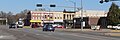 Street scene
 -
 Bone Creek Museum of Agrarian Art
 -
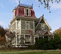 Chauncey S. Taylor House
 -
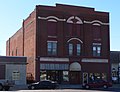 Thorpe Opera House
 -
 Butler County Courthouse
 -
 David City park W entrance
 -
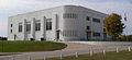 David City Municipal Auditorium


References
- ^ "ArcGIS REST Services Directory". United States Census Bureau. Retrieved September 18, 2022.
- ^ a b U.S. Geological Survey Geographic Names Information System: David City, Nebraska
- ^ "Find a County". National Association of Counties. Archived from the original on May 31, 2011. Retrieved June 7, 2011.
- ^ "David City, Butler County". Center for Advanced Land Management Information Technologies. University of Nebraska. Retrieved July 31, 2014.
- ^ a b c d Elton A. Perkey (2003). Perkey's Nebraska Place Names (4th ed.). Nebraska State Historical Society. p. 22.
- ^ Gannett, Henry (1905). The Origin of Certain Place Names in the United States. Govt. Print. Off. pp. 100.
- ISBN 0803250606. Retrieved December 13, 2014.
- ^ a b "History", David City, Nebraska,
The courthouse site was owned by Mrs. Phoebe Davids Miles, who donated the land for the structure. The town was named in honor of her late father, William Davids of Marion, Ohio. The "s" in the name was dropped and the town became David City, the only town in the world with this name.
- ^ "US Gazetteer files 2010". United States Census Bureau. Archived from the original on January 12, 2012. Retrieved June 24, 2012.
- ^ "NOWData - NOAA Online Weather Data". National Oceanic and Atmospheric Administration. Retrieved April 2, 2024.
- ^ "Summary of Monthly Normals 1991-2020". National Oceanic and Atmospheric Administration. Retrieved April 2, 2024.
- ^ United States Census Bureau. "Census of Population and Housing". Retrieved October 19, 2013.
- ^ "Annual Estimates of the Resident Population: April 1, 2010 to July 1, 2012". Archived from the original on October 19, 2013. Retrieved October 19, 2013.
- ^ "U.S. Census website". United States Census Bureau. Retrieved June 24, 2012.
- ^ a b "David City Public Schools". www.davidcitypublicschools.org. Retrieved January 26, 2019.
- ^ Telegram, Columbus. "Banner-press". Columbus Telegram. Retrieved January 26, 2019.
External links
 | ||||
Villages | ||||
| Townships | ||||
| Unincorporated communities | ||||
| Ghost town | ||||
| ||||
| Authority control databases: Geographic |
|---|