
De Knipe
De Knipe | ||
|---|---|---|
Village | ||
 The Skoatterlânske Kompanjonsfeart in De Knipe | ||
|
Postal code 8456[1] | ||
| Dialing code | 0513 | |
De Knipe (archaic: Dutch: De Knijpe) is a village in the municipality (Dutch: Gemeente) Heerenveen in the province of Friesland, the Netherlands. It had a population of around 1,455 in January 2017.[3]
History
The village was first mentioned in 1622 as Nieubrongerga1. De Knipe means artificial narrowing of a stream, and refers to the
Mennonite church dates from 1751. In 1840, Boven-Knijpe was home to 571 people and Beneden-Knijpe had a population of 643 people.[5]
Gallery
-
 Canal view
 -
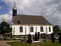 Protestant church
 -
 Mennonite church
 -
 Hemp harvest


References
- ^ a b c "Kerncijfers wijken en buurten 2021". Central Bureau of Statistics. Retrieved 30 March 2022.
- ^ "Postcodetool for 8456AA". Actueel Hoogtebestand Nederland (in Dutch). Het Waterschapshuis. Retrieved 30 March 2022.
- ^ Kerncijfers wijken en buurten 2017 - CBS Statline
- ^ "De Knipe - (geografische naam)". Etymologiebank (in Dutch). Retrieved 30 March 2022.
- ^ "De Knipe". Plaatsengids (in Dutch). Retrieved 30 March 2022.
External links
![]() Media related to De Knipe at Wikimedia Commons
Media related to De Knipe at Wikimedia Commons
This Friesland location article is a stub. You can help Wikipedia by expanding it. |