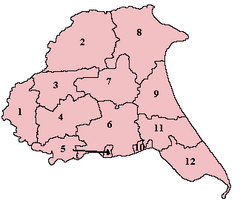
Dickering Wapentake
Appearance

Dickering was a
Domesday hundreds of Burton,[1] Huntou (Hunthow)[2] and Torbar.[3] The Wapentake of Dickering ceased to have much significance in the 19th century when the wapentakes were superseded by other administrative divisions for most local government purposes.[4]
Dickering consisted of the parishes of
Ganton, Garton on the Wolds, Hunmanby, Kilham, Langtoft, Lowthorpe, Muston, Nafferton, Reighton, Rudston, Ruston Parva, Thwing, Willerby and Wold Newton, and part of the parish of Filey.[5]
References
- ^ Open Domesday: Burton Hundred. Accessed 2 November 2021.
- ^ Open Domesday: Hunthow Hundred. Accessed 2 November 2021.
- ^ Open Domesday: Torbar Hundred. Accessed 2 November 2021.
- ^ "Relationships / unit history of Dickering". A Vision of Britain Through Time. Great Britain Historical GIS Project. Retrieved 13 December 2016.
- )
