
Dobrzyca
This article needs additional citations for verification. (July 2022) |
Dobrzyca | |
|---|---|
Town | |
.jpg) The museum, palace and park complex | |
|
UTC+2 (CEST) | |
| Postal code | 63-330 |
| Area code | +48 62 |
| Car plates | PPL |
| Website | gminadobrzyca.pl |
Dobrzyca [dɔˈbʐɨt͡sa] is a town in Pleszew County, Greater Poland Voivodeship, in west-central Poland. It is the seat of the gmina (administrative district) called Gmina Dobrzyca.[2] It lies approximately 13 kilometres (8 mi) west of Pleszew, 15 kilometres (9 mi) northeast of Jarocin, 25 kilometres (16 mi) from Krotoszyn, and 76 km (47 mi) south-east of the regional capital Poznań. As of December 2021, the town has a population of 3,101.[1]
History
.jpg)
As part of the region of Greater Poland, i.e. the cradle of the Polish state, the area formed part of Poland since its establishment in the 10th century. The first written mention of Dobrzyca dates to 1327, when the noble Mikołaj Dobrzycki took possession of the town. In 1440, King Władysław III of Warna granted town privileges to the community. Dobrzyca was a private town, administratively located in the Kalisz County in the Kalisz Voivodeship in the Greater Poland Province.[3]
Dobrzyca was destroyed by Swedish troops during the
After the
After the
Sites of interest
The Gorzeński Palace and the park are tourist destinations in Dobrzyca. Similar palace designs are in numerous in other places in Poland such as Gołuchów, 20 km east of Dobrzyca, and another at Śmiełów to the north, where a palace was built by the same aristocratic family.
Palace
The palace of Augustyn Gorzeński, designed by
In 1940 to 1941, after the evacuation of the countess Czarnecka and her daughters, the palace was used as a grain storehouse, which contributed to the destruction of the parquet floors. In the postwar years the building served as a primary school. In 1988 it was given over to the National Museum; in 1990 it was restored under a public-private partnership.
Landscape garden
The landscaped park is noteworthy; it was developed at the beginning of the 19th century in the English style. It covers two river courses as well as several ponds and channels. The pavilion represents the Roman Pantheon. On an artificial island, there is a summerhouse and exotic plants, and a monopteros rises from one of the ponds.
-
 The Gorzeński Palace, now a museum, in Dobrzyca.
 -
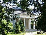 Pantheon in the Park
 -
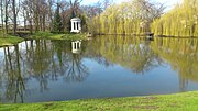 Park and monopteros
 -
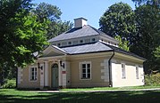 Gardener's house, now a library
.jpg)
.jpg)
.jpg)

References
- ^ a b "Local Data Bank". Statistics Poland. Retrieved 2022-07-30. Data for territorial unit 3020034.
- ^ "Central Statistical Office (GUS) - TERYT (National Register of Territorial Land Apportionment Journal)" (in Polish). 2008-06-01.
- ^ Atlas historyczny Polski. Wielkopolska w drugiej połowie XVI wieku. Część I. Mapy, plany (in Polish). Warszawa: Instytut Historii Polskiej Akademii Nauk. 2017. p. 1b.
External links
| Town and seat |  | |
|---|---|---|
| Villages | ||
| Authority control databases: National |
|---|