
Draft:Ermenonville Forest
You can help expand this article with text translated from the corresponding article in French. (July 2013) Click [show] for important translation instructions.
|
[other content already published]
Natural heritage
Protections
The Ermenonville Forest is protected for its landscapes, its natural environments, and the species living there. It has been part of a DREAL/UDAP listed site since 28 August 1998. The site, which includes the Ermenonville Forest, the Pontarmé Forest (part of the Chantilly Forest), the Haute Pommeraie Forest, and the Saint-Christophe hill in the Forest of Halatte, covers 15,000 ha (58 sq mi).[1] The Vallière estate has been a listed place in its own right since 10 April 1961, covering 330 ha (1.3 sq mi).[2]
The forest unit can be divided into three zones naturelles d'intérêt écologique, faunistique et floristique, which provide a good understanding of its natural diversity:
- the "Chantilly/Ermenonville forest unit", a type 1 ZNIEFF of 11,048 ha (42.66 sq mi) total, covering the national forest as well as the Vallière estate, the Chantilly forest in 19 Oise communes, and the eastern Monlognon woods;[3]
- the "Bois de Morriére", a type 1 ZNIEFF covering 1,099 ha (4.24 sq mi) of private woods southwest of the national forest;[4]
- and the "Interforest exchange area / large mammal route from Retz to Ermenonville", which does not cover the Ermenonville Forest itself, but rather a wildlife corridor between it and the Forest of Retz to the east.[5]
-
 Scots pine and fernsare ubiquitous in the central part of the forest (here, the GR 1 near the Sycomore crossroads).
 -
 Scots pine high forest at the west edge of the national forest.
 -
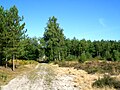
 The forest has low topographical relief but is dotted with small hills in several areas. Its sandy substrate and its vegetation contribute to a Mediterranean ambience.
 -
 In the Bois de Perthe, deciduous trees are much more common than in the main forest unit. Here, an oak forest to the east of the wood, near Montagny-Sainte-Félicité.
 -
 The Bois de Perthe has much greater topographical relief than that of the rest of the forest; here, the Regard route between the Perthe post and the Desert.


Since April 2006, the forest has contained two Natura 2000 sites. As such, it is subject to management regimens to maintain the species in question and the habitats they occupy:[6]
- The "Picardy forests: Trois Forêts and Bois du Roi units" special protection zone covers 13,615 ha (52.57 sq mi), including almost all the surrounding forest and woodlands. This zone is especially focused on protection of bird species, particularly its 12 species of concern;[7]
- The "Forest units of Halatte, Chantilly, and Ermenonoville" covers 2,396 ha (5,920 acres). Only a small part of this unit is in the Ermenonville Forest: part of the edge of the Butte aux Gens d'Armes in the Chantilly Forest, the area of the Thève valley and the Vallière ponds, part of the Morrière woods, and a small portion of the Perthe and Montlognon woods. It protects 18 different types of habitats, about 20 protected and 60 threatened plant species, and four rare animal species.[8]
All communes covered by the Forest have been part of the Parc naturel régional Oise-Pays de France (Oise - Pays de France Regional Natural Park) since its creation in 2004.
Flora and fauna
The forest hosts many large animals, including wild boar, red deer, and roe deer, as well as European green woodpecker in the conifer zones.
In the 18th century, moorland covered about 3,000 ha (12 sq mi), almost the entire area of the modern national forest. About 200 ha (490 acres) remain today; this is significantly more than in the neighboring Chantilly Forest and Forest of Halatte units. Since its creation in 2004, the Oise-Pays de France Regional Natural Park has been studying these remnant heaths and taking
-
 Moorland and Scots pines in the national forest, north of Poteau Ste-Marguerite, plot 162
 -
 Bell heather, Haute-Chaume road, plot 130, in active restoration area
 -
 Haute-Chaume road between plots 131 and 141; in the background, the Haute-Chaume post. This is the main moorland area under restoration.
 -
 Moors in the Morrière woods, at the Pierre Monconseil site, Plailly.


The main heathland areas of the Ermenonville forest are as follows:
- the Bruyères de Frais-Vent in the northern Montlognon Woods, property of the Institut de France, plots 52 and 54
- Haute-Chaume, 5 ha (12 acres), plots 131 and 141 in the national forest, on either side of the Haute-Chaume road;
- the area west of the N 330 road at the Bosquet du Prince crossroads, national forest plots 69, 70, and 110
- the Pierre Monconseil, in the private Morrière Woods (closed to the public), southwest of Parc Astérix
- Mer de Sable inside Parc Astérix
- Butte du Malois inside the Mortefontaine golf course, and related areas inside the CERAM test tracks
Two other moorland areas near the Ermenonville Forest were included in the preservation program: the Butte aux Gens d'Armes in the Pontarmé Forest (part of the Chantilly Forest unit) and the Garenne Maillard, a private woods east of La Chapelle-en-Serval near Château Mont-Royal.[9]
Notable places
Notable trees
L'Ancêtre de Perthe ("the Perthe Ancestor") is a large oak located in the Bois de Perthe, east of Ermenonville. It is 37 m (121 ft) tall and 250 years old as of 2002.
-
 Ancêtre de Perthe, 8 mai 2016.
 -
 Ancêtre de Perthe, 8 mai 2016.
 -
 Ancêtre de Perthe, 8 mai 2016.


Notable natural sites
-
 The Bruyères de Frais-Vent in the Montlognon woods, previously a sandstone quarry, is the Ermenonville Forest's main site of geological interest.
 -
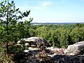 View of the Mer de Sable from one of the Bruyères de Frais-Vent hills.
 -
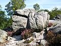 Despite 19th-century exploitation as a quarry, naturally-formed sandstone blocks can still be found.
 -
 View of the Château de Vallière from the natural promontory of Pierre Monconseil, south of Parc Asterix with its noise pollution.
.jpg)
.jpg)
.jpg)

The Ermenonville Forest has four main publicly-accessible sandstone block areas.
- The Bruyères de Frais-Vent site, located in the Montlognon woods on the Chaalis estate (Institut de France lands), is the most impressive. Several small hills covered with sandstone blocks and moor vegetation mingle with stretches of sand, framed by pines and heather. The site was quarried for sandstone in the 19th century[10][11], and it is difficult to determine how much of its current state is natural and how much is human-modified.
- The Pierre Monconseil site is located in the private Morrière Woods, north of Plailly. It is also a former quarry and is floristically similar to the Bruyères de Frais-Vent. Here, the sandstone blocks are generally much smaller; despite the name ("Counsel Rock"), there is no single large stone here.
- The Grès Sainte-Marguerite, visible from the Chemin du Frêne (especially plots 163 and 166) is located on the north edge of the Vallière estate and named after the estate's chapel of St. Margaret. The small rocks here are only partly visible under a covering of vegetation, ferns, and pine-needle litter.
- The Pierre Sorcière is an impressive large rock located in Perthe Woods, at the northwest end of plot 261 near the Basse-Corde crossroads. From the Patte d'Oie route, access is only to a rocky plateau with a (tree-obstructed) view of the Ermenonville Forest and the Mer de Sable; from the road to Motagny, the rock itself is visible atop the hill, far from the route and partly hidden in ferns.
[MORE TO COME]
"La forêt d'Ermenonville compte en outre cinq étangs[...]"
References
- ^ "Fiche descriptive du site classé des forêts d'Ermenonville, de Pontarme, de Haute-Pommeraie, clairière et butte de Saint-Christophe" (PDF). Retrieved 17 April 2010.
- ^ "Fiche descriptive du site classé du domaine de Vallière" (PDF). Retrieved 17 April 2010.
- ^ "Fiche descriptive de la ZNIEFF massif forestier Chantilly/Ermenonville". DREAL Picardie. Retrieved 17 April 2010.
- ^ "Fiche descriptive de la ZNIEFF bois de Morrière". DREAL Picardie. Retrieved 17 April 2010.
- ^ "Fiche descriptive de la ZNIEFF Site d'échanges interforestiers (passage de grands mammifères) de Retz à Ermenonville". DREAL Picardie. Retrieved 16 October 2009.
- ^ "Natura 2000 : Les sites des Trois Forêts et du bois du Roi". Retrieved 16 October 2009.
- ^ "Site Natura 2000 : Forêts picardes : massif des trois forêts et bois du roi". Retrieved 17 April 2010.
- ^ "Massifs forestiers d'Halatte, de Chantilly et d'Ermenonville, site d'importance communautaire". Retrieved 17 April 2010.
- ^ Cf. le magazine du parc, "Soyons parc, n° 16" (PDF)., p. 5-7.
- ^ Cite error: The named reference
Corpartwas invoked but never defined (see the help page). - ^ Cite error: The named reference
9,12was invoked but never defined (see the help page).