
Dunlop Parish (Yanda County)
| Dunlop Parish Federal division(s) | Parkes | |
|---|---|---|
Dunlop Parish is a
Location
The Parish is on the
.The only town of the parish is Louth, New South Wales.
Geography
The topography is flat with a Köppen climate classification of BsK (Hot semi arid).[9]
The economy in the parish is based on broad acre agriculture, mainly Wheat, and sheep.
-
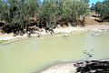 Darling River Dunlop Parish
 -
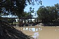 Louth bridge 1.JPG Dunlop Parish
 -


_Australia.png)
The Dunlop Ranges are in the parish.
History
The
The first European to the area was Thomas Mitchell (explorer).In 1859 when Thomas Andrew Mathews, an Irish immigrant from County Louth, built a pub to serve the passing trade along the Darling River.
In 1888 the first mechanised shearing of sheep, in the world, took place at Sir Samuel McCaughey's Dunlop Station.[12]
External links
- Charles Bayliss, View from Dunlop Range, near Louth, Darling River looking south (1886).
- Charles. Bayliss, Homestead, Dunlop Station, Darling River (1886) , National Gallery of Victoria, Melbourne.
References
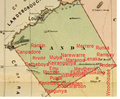
- ^ Map of the County of Yanda, Western Division, NSW 1918.
- ^ [cartographer] C.A. Orwin, [https://nla.gov.au/nla.obj-233873384/view Map of the County of Rankin : Western Division, Land Districts of Bourke, Cobar and Wilcannia, N.S.W. 1912 (New South Wales. Department of Lands Title, Sydney N.S.W. 1914).
- ^ "Rankin". Geographical Names Register (GNR) of NSW. Geographical Names Board of New South Wales. Retrieved 4 August 2013.
- ^ The New atlas of Australia (John Sands, 1886) map 24.
- ^ Yanda County Archived 6 May 2018 at the Wayback Machine, GEOGRAPHICAL NAMES REGISTER EXTRACT.
- ^ / The New atlas of Australia, (John Sands, 1886), map 24.
- ^ [cartographer] C.A. Orwin, [https://nla.gov.au/nla.obj-233873384/view Map of the County of Rankin : Western Division, Land Districts of Bourke, Cobar and Wilcannia, N.S.W. 1912 (New South Wales. Department of Lands Title, Sydney N.S.W. 1914).
- ^ The New atlas of Australia (John Sands, 1886) map 24.
- ISSN 1027-5606. (direct: Final Revised Paper)
- ^ Norman Tindale's Catalogue of Australian Aboriginal Tribes
- AIATSIS.
- ^ Trilby Station Archived 2 April 2012 at the Wayback Machine Retrieved 26 September 2011