
East Barnet Urban District
| East Barnet East Barnet Valley (1874–1935) | |
|---|---|
| Local Government District (1874–1894) Urban District (1894–1965) | |
 | |
| Area | |
| • 1911 | 2,644 acres (10.70 km2)[1] |
| • 1961 | 2,644 acres (10.70 km2)[1] |
| Population | |
| • 1911 | 12,381[1] |
| • 1961 | 40,641[1] |
| History | |
| • Created | 1 October 1874 |
| • Abolished | 31 March 1965 |
| • Succeeded by | London Borough of Barnet |
| Status | Urban district (1894–1965) |
| Government | East Barnet Valley Local Board (1874–1894) East Barnet Valley Urban District Council (1894–1935) East Barnet Urban District Council (1935–1965) |
| • HQ | Station Road, New Barnet |
| • Motto | Willingness rids way |
 Coat of arms[2] | |
East Barnet Valley was a local government district from 1874 to 1965 around the town of East Barnet. It was partly in the counties of Hertfordshire and Middlesex until 1889, when the Middlesex part was transferred to Hertfordshire. It was renamed East Barnet in 1935.
Creation
The district was created on 1 October 1874, as East Barnet Valley Local Government District.[3] The district was governed by a local board. Apart from the parish of East Barnet, the local board's area included parts of the neighbouring parishes of Chipping Barnet in Hertfordshire and Monken Hadley in Middlesex.[4]
Reform
In 1889 Middlesex was reduced locally by the Local Government Act 1888: East Barnet Valley became entirely part of Hertfordshire.
The
- East Barnet (1,697 acres)
- Barnet Vale (the area formerly in Chipping Barnet parish) (279 acres)
- Monken Hadley (the parts formerly in Middlesex) (668 acres)
The urban district was renamed East Barnet in 1935.[5]
The district formed part of a long, thin protrusion into Middlesex and was surrounded by that county on three sides; to the north, east and south.
Coat of arms
The urban district council adopted an unofficial
Abolition
In 1965 the urban district was abolished by the London Government Act 1963 and its former area transferred from Hertfordshire to Greater London . Its former area was combined with that of other districts to form the present-day London Borough of Barnet.
Population
The area of the urban district was 2,644 acres (10.7 km2). The population, as returned at the census, was:
| Year | 1901 | 1911 | 1921 | 1931 | 1941 | 1951 | 1961 |
|---|---|---|---|---|---|---|---|
| Population | 10,094 | 12,381 | 13,514 | 18,549 | [8] | 40,408 | 40,641 |
Politics
The urban district was divided into seven wards for elections: Brunswick Park, Cockfosters, East Barnet, Hadley, Lyonsdown, New Barnet and Osidge.
Urban District council
Parliament constituency
For elections to Parliament, the urban district was part of the constituency of:
In 1945 St Albans was divided as an emergency measure because its electorate exceeded 100,000 voters, with the urban district becoming part of the new constituency of:
Gallery
-
 In 1961: 1 is Barnet and 2 is East Barnet
 -
 District in 1863.
 -
 District in 1894.
 -
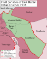 District in 1935.


References
- ^ a b c d Great Britain Historical GIS / University of Portsmouth, East Barnet UD population (area ). Retrieved 2008-01-26.
- ^ "East Barnet - Coat of arms (crest) of East Barnet". Heraldry of the World. Retrieved 9 August 2022.
- ^ "Local Government Board's Provisional Orders Confirmation (No. 4) Act 1874". legislation.gov.uk. The National Archives. Retrieved 13 April 2024.
- ^ Frederic A Youngs Guide to the Local Administrative units of England, Volume I: Southern England, London 1979
- ^ Great Britain Historical GIS / University of Portsmouth, East Barnet UD. Retrieved 2008-01-26.
- ^ C W Scott-Giles, Civic Heraldry of England and Wales, 2nd edition, London 1953
- ^ Civic Heraldry of England and Wales: Hertfordshire (obsolete), accessed January 26, 2007
- ^ The census was suspended for World War II