
Ebersdorf bei Coburg
Ebersdorf b.Coburg | |
|---|---|
 Protestant church | |
 Coat of arms | |
Location of Ebersdorf b.Coburg within Coburg district 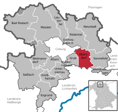 | |
Ortsteile | |
| Government | |
| • Mayor (2020–26) | Bernd Reisenweber[1] |
| Area | |
| • Total | 26.50 km2 (10.23 sq mi) |
| Elevation | 310 m (1,020 ft) |
| Population (2022-12-31)[2] | |
| • Total | 6,218 |
| • Density | 230/km2 (610/sq mi) |
| Time zone | UTC+01:00 (CET) |
| • Summer (DST) | UTC+02:00 (CEST) |
| Postal codes | 96237 |
| Dialling codes | 09562 |
| Vehicle registration | CO |
| Website | www.ebersdorf.de |
Ebersdorf bei Coburg is a municipality in the district of Coburg in Bavaria in Germany.
Geography
Location
Ebersdorf lies on the upper course of the river Füllbach, a tributary of the Itz, and at the northern edge of the Lichtenfels Forest (Lichtenfelser Forst).
Subdivisions
Ebersdorf is divided into 6 Ortsteile:
Transport
Ebersdorf can be reached by car via
Inner German Border
and was later lifted in 2000.
References
- Bayerisches Landesamt für Statistik, 15 July 2021.
- ^ Genesis Online-Datenbank des Bayerischen Landesamtes für Statistik Tabelle 12411-003r Fortschreibung des Bevölkerungsstandes: Gemeinden, Stichtag (Einwohnerzahlen auf Grundlage des Zensus 2011) (Hilfe dazu).
Towns and municipalities in Coburg (district) | ||
|---|---|---|
 | ||
| International | |
|---|---|
| National | |
This Coburg district location article is a stub. You can help Wikipedia by expanding it. |