
Eckerwald Memorial

The Eckerwald Memorial (approx. 15km southwest of
Schörzingen concentration camp built a shale oil
factory on this site during a construction period of about three months.
The Memorial is located outside the village of Schörzingen, today a district of
Swabian Alb
.
The plant was one of ten production sites of the
Natzweiler-Struthof
concentration camp for experimental purposes and for the production of shale oil in order to work in them subsequently.
On the grounds of the Memorial site, a bronze sculpture in a trough excavated by prisoners commemorates the events.[1]
The Memorial is a member of the Gäu-Neckar-Alb Memorials Network and the Natzweiler Memorials Network in the former concentration camp complex.[2][3]
-
 Eckerwald Memorial Site (Swabian Alb, near Schömberg); one memorial place of the Operation 'Wüste' (desert)
 -
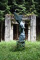 Eckerwald Memorial Site: bronze statue of the artist Siegfried Haas with the inscription: Macht ist Ohnmacht ("power is insensibility"). Deployed in summer 2004.
 -
 Eckerwald Memorial Site: ruins of the gas purification base construction
 -
 Documentation center inside the ruin of the gas purification factory. The incidents of the Unternehmen Wüste are described in ten showcases


External links
References
- ^ "Gedenkstätte Eckerwald". www.eckerwald.de. Retrieved 2019-04-02.
- ^ "Übersicht - Gedenkstättenverbund Gäu-Neckar-Alb". 2018-04-03. Archived from the original on 2018-04-03. Retrieved 2019-04-02.
- ^ "Mitglieder". 2018-12-21. Archived from the original on 2018-12-21. Retrieved 2019-04-02.