
Effingham, New Hampshire
Effingham, New Hampshire | ||
|---|---|---|
Town | ||
FIPS code 33-23620 | | |
| GNIS feature ID | 0873588 | |
| Website | www | |
Effingham is a town in Carroll County, New Hampshire, United States. At the 2020 census, the town population was 1,691,[2] up from 1,465 at the 2010 census.[3] Effingham includes the villages of Effingham Falls, Effingham (Lord's Hill), Center Effingham (Drake's Corner), and South Effingham. Pine River State Forest is in the south.
History
The town was settled by members of the Leavitt family of Hampton, New Hampshire, led by Captain John Leavitt, a soldier whose father, Moses, was a prosperous Hampton tavern keeper. From them the settlement first took the name "Leavitt's Town".[4] In 1749, the land was granted by Governor Benning Wentworth, and he renamed it "Effingham" for the Howard family, who were Earls of Effingham and who were related to the Wentworths by marriage. The town was incorporated in 1778.
North Effingham was set off in 1831 and incorporated as Freedom. By 1859, when the population was 1,252, Effingham Falls had developed into a small mill town, with a woolen factory, five sawmills, three gristmills, and a carriage factory.[5]
Per a
-
 Post Office in 1908
 -
 Lord Mansion in 1908
 -
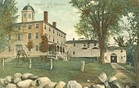
 Normal School in 1910
 -
 Effingham Falls in 1915


Geography
According to the
The town is served by state routes 25 and 153.
Adjacent municipalities
- Freedom (north)
- Parsonsfield, Maine (east)
- Wakefield (southeast)
- Ossipee (west)
Demographics
| Census | Pop. | Note | %± |
|---|---|---|---|
| 1790 | 154 | — | |
| 1800 | 451 | 192.9% | |
| 1810 | 876 | 94.2% | |
| 1820 | 1,368 | 56.2% | |
| 1830 | 1,911 | 39.7% | |
| 1840 | 1,195 | −37.5% | |
| 1850 | 1,252 | 4.8% | |
| 1860 | 1,209 | −3.4% | |
| 1870 | 904 | −25.2% | |
| 1880 | 865 | −4.3% | |
| 1890 | 720 | −16.8% | |
| 1900 | 600 | −16.7% | |
| 1910 | 558 | −7.0% | |
| 1920 | 393 | −29.6% | |
| 1930 | 352 | −10.4% | |
| 1940 | 377 | 7.1% | |
| 1950 | 341 | −9.5% | |
| 1960 | 329 | −3.5% | |
| 1970 | 360 | 9.4% | |
| 1980 | 599 | 66.4% | |
| 1990 | 941 | 57.1% | |
| 2000 | 1,273 | 35.3% | |
| 2010 | 1,465 | 15.1% | |
| 2020 | 1,691 | 15.4% | |
| U.S. Decennial Census[2][9] | |||
As of the
There were 490 households, out of which 29.0% had children under the age of 18 living with them, 53.5% were married couples living together, 10.6% had a female householder with no husband present, and 31.4% were non-families. Of all households, 23.3% were made up of individuals, and 7.6% had someone living alone who was 65 years of age or older. The average household size was 2.43 and the average family size was 2.88.
In the town, the population was spread out, with 26.0% under the age of 18, 6.6% from 18 to 24, 29.2% from 25 to 44, 25.6% from 45 to 64, and 12.6% who were 65 years of age or older. The median age was 38 years. For every 100 females, there were 106.7 males. For every 100 females age 18 and over, there were 106.1 males.
The median income for a household in the town was $36,000, and the median income for a family was $38,000. Males had a median income of $29,650 versus $22,188 for females. The
See also
References
- ^ a b "2021 U.S. Gazetteer Files – New Hampshire". United States Census Bureau. Retrieved November 1, 2021.
- ^ a b c "Effingham town, Carroll County, New Hampshire: 2020 DEC Redistricting Data (PL 94-171)". U.S. Census Bureau. Retrieved November 1, 2021.
- ^ United States Census Bureau, American FactFinder, 2010 Census figures. Retrieved March 23, 2011.
- ISBN 0-87233-009-5.
- ^ Coolidge, Austin J.; John B. Mansfield (1859). A History and Description of New England. Boston, Massachusetts: A.J. Coolidge. pp. 483–484.
coolidge mansfield history description new england 1859.
- ^ "83. First Normal School in New Hampshire". geocities.ws. Retrieved February 5, 2024.
- ^ Foster, Debra H.; Batorfalvy, Tatianna N.; Medalie, Laura (1995). Water Use in New Hampshire: An Activities Guide for Teachers. U.S. Department of the Interior and U.S. Geological Survey.
- ^ "Ossipee Aquifer Protection". Green Mountain Conservation Group. Retrieved November 1, 2021.
- ^ "Census of Population and Housing". Census.gov. Retrieved June 4, 2016.
- ^ "U.S. Census website". United States Census Bureau. Retrieved January 31, 2008.
External links
- Official website
- Effingham Public Library
- Historic Town Hall-Library
- New Hampshire Economic and Labor Market Information Bureau Profile
Places adjacent to Effingham, New Hampshire | |
|---|---|
Municipalities and communities of Carroll County, New Hampshire, United States | ||
|---|---|---|
| Towns |  | |
| Township | ||
| CDPs | ||
Other villages | ||
| ||
| International | |
|---|---|
| National | |