
Hiram, Maine
Hiram, Maine | ||
|---|---|---|
FIPS code 23-33315 | | |
| GNIS feature ID | 0582520 | |
Hiram is a town in
History
It became a stage stop along the Pequawket Trail, the former wilderness path of the Sokokis Abenakis which runs from Standish to Fryeburg (site of Pequawket, their stockaded village). First known as Great Ossipee after the Ossipee River, the town was settled in the 1780s and organized as Hiram Plantation, named after Hiram I, the biblical king of Tyre.[3][4] Like King Hiram's domain, Hiram Plantation was set among forests. It was incorporated as a district on February 27, 1807, then as the town of Hiram on June 14, 1814. Peleg Wadsworth bought a tract of land here in 1790, and in 1792 or 1794 began clearing a farm for his eldest son.[5]
Although uneven at the center, there was good and fertile
The
-
 Bucknell House c. 1915, built in 1792 near the Saco
 -
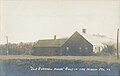
 Mt. Cutler House in 1909, early stage stop and hotel
 -
 Railroad bridge across the Saco River in 1916


Geography
According to the United States Census Bureau, the town has a total area of 38.87 square miles (100.67 km2), of which 37.55 square miles (97.25 km2) is land and 1.32 square miles (3.42 km2) is water.[1] Hiram is drained by the Ossipee River and Saco River.
The town is crossed by state routes 5, 113, 117, and 160. It is bordered by the towns of Brownfield and Denmark to the north, Porter to the west, Sebago and Baldwin to the east, and Cornish and Parsonsfield to the south.
Climate
This
Demographics
| Census | Pop. | Note | %± |
|---|---|---|---|
| 1790 | 92 | — | |
| 1800 | 184 | 100.0% | |
| 1810 | 336 | 82.6% | |
| 1820 | 700 | 108.3% | |
| 1830 | 1,026 | 46.6% | |
| 1840 | 1,233 | 20.2% | |
| 1850 | 1,210 | −1.9% | |
| 1860 | 1,283 | 6.0% | |
| 1870 | 1,393 | 8.6% | |
| 1880 | 1,452 | 4.2% | |
| 1890 | 1,063 | −26.8% | |
| 1900 | 1,015 | −4.5% | |
| 1910 | 945 | −6.9% | |
| 1920 | 921 | −2.5% | |
| 1930 | 813 | −11.7% | |
| 1940 | 787 | −3.2% | |
| 1950 | 804 | 2.2% | |
| 1960 | 699 | −13.1% | |
| 1970 | 686 | −1.9% | |
| 1980 | 1,067 | 55.5% | |
| 1990 | 1,260 | 18.1% | |
| 2000 | 1,423 | 12.9% | |
| 2010 | 1,620 | 13.8% | |
| 2020 | 1,609 | −0.7% | |
| U.S. Decennial Census[9] | |||

2010 census
As of the
There were 652 households, of which 31.4% had children under the age of 18 living with them, 50.6% were married couples living together, 11.0% had a female householder with no husband present, 4.6% had a male householder with no wife present, and 33.7% were non-families. 26.5% of all households were made up of individuals, and 8.9% had someone living alone who was 65 years of age or older. The average household size was 2.48 and the average family size was 3.00.
The median age in the town was 41.3 years. 25.1% of residents were under the age of 18; 7% were between the ages of 18 and 24; 23.2% were from 25 to 44; 30.9% were from 45 to 64; and 13.7% were 65 years of age or older. The gender makeup of the town was 51.4% male and 48.6% female.
2000 census
As of the
There were 534 households, out of which 36.3% had children under the age of 18 living with them, 60.1% were married couples living together, 8.6% had a female householder with no husband present, and 27.3% were non-families. 19.5% of all households were made up of individuals, and 7.3% had someone living alone who was 65 years of age or older. The average household size was 2.66 and the average family size was 3.07.

In the town, the population was spread out, with 27.8% under the age of 18, 6.4% from 18 to 24, 29.4% from 25 to 44, 25.7% from 45 to 64, and 10.8% who were 65 years of age or older. The median age was 37 years. For every 100 females, there were 99.3 males. For every 100 females age 18 and over, there were 99.8 males.
The median income for a household in the town was $34,167, and the median income for a family was $36,964. Males had a median income of $27,784 versus $22,500 for females. The
Local schools
- Sacopee Valley Middle School
- Sacopee Valley High School
Notable people
- Contessa Brewer, MSNBC anchorwoman
- Charles Cleaves Cole, federal judge
- Henry Wadsworth Longfellow, poet
- Peleg Wadsworth, general, founded Hiram
References
- ^ a b "US Gazetteer files 2010". United States Census Bureau. Retrieved December 16, 2012.
- ^ "Census - Geography Profile: Hiram town, Oxford County, Maine". Retrieved January 19, 2022.
- ^ Maine League of Historical Societies and Museums (1970). Doris A. Isaacson (ed.). Maine: A Guide 'Down East'. Rockland, Me: Courier-Gazette, Inc. p. 411.
- ^ Gannett, Henry (1905). The Origin of Certain Place Names in the United States. Govt. Print. Off. p. 157.
- ^ Austin J. Coolidge & John B. Mansfield, A History and Description of New England; Boston, Massachusetts
- ^ Hayward's New England Gazetteer of 1839
- ^ George J. Varney, History of Hiram, Maine, Boston, Massachusetts 1886
- ^ Climate Summary for Hiram, Maine
- ^ "Census of Population and Housing". Census.gov. Retrieved June 4, 2015.
- ^ "U.S. Census website". United States Census Bureau. Retrieved December 16, 2012.
- ^ "U.S. Census website". United States Census Bureau. Retrieved January 31, 2008.
External links
- Town of Hiram official website
- Soldiers Memorial Library
- Maine.gov – Hiram, Maine
- Maine Genealogy: Hiram, Oxford County, Maine
Municipalities and communities of Oxford County, Maine, United States | ||
|---|---|---|
| Towns |  | |
| Plantations | ||
| Unorganized territories | ||
| CDPs | ||
| Other villages | ||
| Footnotes | ‡This populated place also has portions in an adjacent county | |
| ||
43°52′43″N 70°48′12″W / 43.87861°N 70.80333°W
| International | |
|---|---|
| National | |