
Elyashiv
Elyashiv
אֶלְיָשִׁיב إلياشيف | |
|---|---|
 | |
 Elyashiv  Elyashiv | |
| Coordinates: 32°22′48″N 34°54′35″E / 32.38000°N 34.90972°E | |
| Country | |
| District | Central |
| Council | Hefer Valley |
| Affiliation | Hitahdut HaIkarim |
| Founded | 13 November 1933 |
| Founded by | Yemenite Jews |
| Population (2022)[1] | 715 |
Elyashiv (Hebrew: אֶלְיָשִׁיב, lit. God will bring back) is a moshav in central Israel. Located in the Sharon plain, it falls under the jurisdiction of Hefer Valley Regional Council. In 2022 it had a population of 715.[1]
History
The moshav was founded on a site once occupied by the Arab village Khirbet esh Sheikh Mohammed ("The ruin of Sheikh Mohammed").[2][3][4] Kh. esh Sheikh Muhammed became settled during the rule of Ibrahim Pasha, either by Egyptians or by hamulas (extended families) from mountain villages.[5] In 1882, the PEF's Survey of Western Palestine found that it consisted of a few adobe huts among ruins.[6] Ancient glazed pottery has been found there.[3]
Although Yemenite neighborhoods had been established near many agricultural settlements, it was not until 1930 that independent Yemenite settlements were approved.
The land for the moshav was provided by the
The population was 310 in 1945 and 460 in 1952.[8][15]
-
 Elyashiv 1939
 -
 Elyashiv 1939 1:20,000
 -
 Vicinity of Yemenite moshav Elyashiv in 1941, with location of modern roads added in green
 -
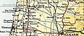 Elyashiv 1945 1:250,000


References
- ^ a b "Regional Statistics". Israel Central Bureau of Statistics. Retrieved 21 March 2024.
- ^ Survey of Palestine (1941). QAQŪN (Map). 1:20000. Topocadrastal series. Archived from the original on 2015-11-17. Retrieved 2015-11-16.
- ^ a b Pringle, 1986, p. 71
- ^ Palmer, 1881, p. 175
- ^ Karmon, The Sharon. Cited in Karmon, 1960, p. 246
- ^ Conder and Kitchener, 1882, SWP II, p. 135
- ^ a b c d Sharaby, 1998, p.21
- ^ a b State of Israel, Government Year-Book 5713, 1952, p. VI.
- ^ Sharaby, 2001, p. 38.
- ISBN 965-220-423-4
- ^ Adler, 1988, pp. 200–202.
- ^ Sharaby, 2001, p. 41.
- ^ Sharaby, 1998, p. 34.
- ^ Sharaby, 1998, and Sharaby, 2001, passim.
- ^ Government of Palestine, Village Statistics 1945, p. 20.
Bibliography
- Adler (Cohen), Raya (1988). "The Tenants of Wadi Hawarith: Another view of the Land Question in Palestine". International Journal of Middle East Studies. 20 (2): 197–220. S2CID 163346325.
- Conder, C.R.; Kitchener, H.H. (1882). The Survey of Western Palestine: Memoirs of the Topography, Orography, Hydrography, and Archaeology. Vol. 2. London: Committee of the Palestine Exploration Fund.
- Department of Statistics (1945). Village Statistics, April, 1945. Government of Palestine.
- Hadawi, S. (1970). Village Statistics of 1945: A Classification of Land and Area ownership in Palestine. Palestine Liberation Organization Research Center.
- Karmon, Y. (1960). "An Analysis of Jacotin's Map of Palestine" (PDF). Israel Exploration Journal. 10 (3, 4): 155–173, 244–253. Archived from the original (PDF) on 2019-12-22. Retrieved 2015-12-06.
- Palmer, E.H. (1881). The Survey of Western Palestine: Arabic and English Name Lists Collected During the Survey by Lieutenants Conder and Kitchener, R. E. Transliterated and Explained by E.H. Palmer. Committee of the Palestine Exploration Fund.
- Denys R. Pringle (1986). The Red Tower (al-Burj al-ahmar): Settlement in the Plain of Sharon at the time of the Crusaders and the Mamluks A.D. 1099–1516. Jerusalem Monograph Series no. 1. London: British School of Archaeology in Jerusalem.
- Sharaby, Rachel (1998). "Farming and Ethnic Identity: Yemenite Settlers Confront Modern Agriculture in Israel". The Journal of Israeli History. 19 (2): 21–37. .
- Sharaby, Rachel (2001). "Conflict, Adjustment, and Compromise: The Case of a Yemenite Moshav". The Jewish Journal of Sociology. 43 (1–2): 37–52.
External links
- Survey of Western Palestine, Map 10: IAA, Wikimedia commons
- Google-map
| International | |
|---|---|
| National | |