Fairfax Line

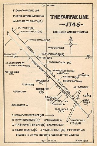
The Fairfax Line was a surveyor's line run in 1746 to establish the limits of the "
The land grant, first contrived in 1649, encompassed all lands bounded by the Potomac and Rappahannock Rivers, an area of 5,282,000 acres (21,380 km2). By 1719, the lands had been inherited by Thomas Fairfax, 6th Lord Fairfax of Cameron (1693–1781). By that time the question of the boundaries of the designated lands had also become highly contentious. In 1745 it was decided that a line between the sources of the North Branch Potomac River and the Rappahannock River would constitute the western limit of Lord Fairfax's lands.
History
Background
The Northern Neck Grant, commonly referred to as the "Fairfax Grant", has its genesis in 1649 when the exiled King Charles II of Britain rewarded the two Colepeper (Culpeper) brothers and five other loyal friends by issuing a grant for a "porcon of Virginia ... bounded by and within the heads of the Rivers Rappahannock and Patawomecke....". The grant actually took force when Charles was restored to the throne in 1660 and it was recorded and a "Proprietary" created in the New World. At that time, the territory encompassed by the grant had not been explored and was not known. The seven original shares ultimately devolved to Thomas Fairfax, 5th Lord Fairfax of Cameron (1657–1710), who married the only child, a daughter named Catherine, of Thomas Colepeper, 2nd Baron Colepeper (1635–89). Thus the Northern Neck grant is commonly referred to as the "Fairfax Grant".
Disputes
The Commonwealth of Virginia frequently disputed the boundaries of the Fairfax Grant. In 1745, the Privy Council in London decided in favor of the 6th Lord Fairfax, designating that "the boundary of the petitioners land doth begin at the first spring of the South Branch of the River Rappahannack now called Rappidan[,] which first spring is the spring of that part of the said River Rappidan as is called in the plans returned by the name of Conway River[,] and that the said boundary be from thence drawn in a straight line North West to the place in the Allagany Mountains where that part of the River Pattawomeck alias Potowmack which is now called Cohongoroota alias Cohongoronton first arises."[1] The imaginary line between the sources of the Conway River and the North Branch Potomac River is commonly referred to as "the Fairfax Line".
Surveys
In 1736
Geography
The Fairfax Line runs in a northwesterly direction for about 77 miles (124 km) through exceptionally rugged terrain: from the crest of the
Notes
- ^ John Wayland, ed. (1990). The Fairfax Line: A Historic Landmark, including "The Fairfax Line: Thomas Lewis's Journal of 1746". New Market, VA: The Henkel Press (1925, reprinted by Shenandoah County Historical Society). p. 12.
References
- The Fairfax Line: Thomas Lewis's Journal of 1746; Footnotes and index by John Wayland, New Market, Virginia: The Henkel Press (1925 publication).
