
Farwell, Michigan
Farwell, Michigan | ||
|---|---|---|
FIPS code 26-27500[4] | | |
| GNIS feature ID | 0625851[5] | |
| Website | Official website | |
Farwell is a village in Clare County in the U.S. state of Michigan. The population was 880 at the 2020 census. The village is located within Surrey Township about 4.0 miles (6.4 km) west of the city of Clare.
Geography
According to the U.S. Census Bureau, the village has a total area of 1.41 square miles (3.65 km2), of which 1.37 square miles (3.55 km2) is land and 0.04 square miles (0.10 km2) (2.84) is water.[3]
The south branch of the Tobacco River flows through the village and contains the Mill Pond reservoir.[6]
Major highways
 M-115 (Main Street) runs west–east through the center of the village.
History
.jpg)
Farwell was founded in 1870 by Edmund Hall, John Van Riper, and George Hitchcock. The Farwell post office opened on January 20, 1871, with George Hitchcock serving as the first postmaster. It was informally platted in 1871 and officially platted the following year by Josiah Littlefield of Ann Arbor. The Flint and Pere Marquette Railroad had plans of expanding into the area on a new route connecting Saginaw to Ludington, which was completed by the end of the decade. The new community was named after New York native Samuel Farwell, who had an interest in the railroad and was a construction contractor. In 1871, Farwell became the first county seat of Clare County but lost the seat of government to Harrison in 1879 after the Farwell courthouse burned down two years earlier. Farwell incorporated as a village in 1879.[7][8]
In 1982, the Rock Road massacre occurred to the west of Farwell in Garfield Township. Due to its proximity to the village, it became known as the "Farwell Murders" and brought national attention to the area.[9]
Demographics
| Census | Pop. | Note | %± |
|---|---|---|---|
| 1880 | 521 | — | |
| 1890 | 584 | 12.1% | |
| 1900 | 535 | −8.4% | |
| 1910 | 522 | −2.4% | |
| 1920 | 449 | −14.0% | |
| 1930 | 422 | −6.0% | |
| 1940 | 538 | 27.5% | |
| 1950 | 694 | 29.0% | |
| 1960 | 737 | 6.2% | |
| 1970 | 777 | 5.4% | |
| 1980 | 804 | 3.5% | |
| 1990 | 851 | 5.8% | |
| 2000 | 855 | 0.5% | |
| 2010 | 871 | 1.9% | |
| 2020 | 880 | 1.0% | |
| U.S. Decennial Census[10] | |||
2010 census
As of the
There were 373 households, of which 28.2% had children under the age of 18 living with them, 41.3% were married couples living together, 15.3% had a female householder with no husband present, 4.8% had a male householder with no wife present, and 38.6% were non-families. 33.0% of all households were made up of individuals, and 16.4% had someone living alone who was 65 years of age or older. The average household size was 2.30 and the average family size was 2.85.
The median age in the village was 40.4 years. 22% of residents were under the age of 18; 8.8% were between the ages of 18 and 24; 23.6% were from 25 to 44; 27.2% were from 45 to 64; and 18.4% were 65 years of age or older. The gender makeup of the village was 48.2% male and 51.8% female.
2000 census
As of the
There were 369 households out of which 27.9% had children under the age of 18 living with them, 41.2% were married couples living together, 13.6% had a female householder with no husband present, and 42.0% were non-families. 34.7% of all households were made up of individuals and 18.4% had someone living alone who was 65 years of age or older. The average household size was 2.28 and the average family size was 2.94.
In the village the population was spread out with 24.6% under the age of 18, 7.6% from 18 to 24, 27.7% from 25 to 44, 22.7% from 45 to 64, and 17.4% who were 65 years of age or older. The median age was 40 years. For every 100 females there were 83.1 males. For every 100 females age 18 and over, there were 75.3 males.
The median income for a household in the village was $24,583, and the median income for a family was $32,917. Males had a median income of $29,063 versus $20,329 for females. The
Education
Farwell is served by its own school district, Farwell Area Schools, which is centralized in the village and also serves several adjacent townships in both Clare and Isabella County.[12]
Images
-
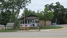 U.S. Post Office in Farwell
 -
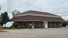 Farwell Village Hall
 -
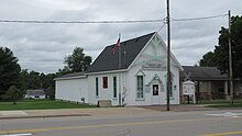 Ladies' Library Association of Farwell
 -
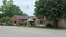 Farwell–Surrey Township Public Library


References
- ^ Village of Farwell (2022). "Village Council". Retrieved September 3, 2022.
- ^ Village of Farwell (2022). "Administrative Staff". Retrieved September 3, 2022.
- ^ a b "2020 U.S. Gazetteer Files". United States Census Bureau. Retrieved May 21, 2022.
- ^ "U.S. Census website". United States Census Bureau. Retrieved January 31, 2008.
- ^ U.S. Geological Survey Geographic Names Information System: Farwell, Michigan
- ^ U.S. Geological Survey Geographic Names Information System: Mill Pond
- ISBN 978-0-8143-1838-6.
- ^ Village of Farwell (2022). "Farwell History". Retrieved September 2, 2022.
- ^ "Small Town in Michigan Feels the Dread That Follows Mass Murder". The New York Times. February 19, 1982. p. 12.
- ^ "Census of Population and Housing". Census.gov. Retrieved June 4, 2015.
- ^ "U.S. Census website". United States Census Bureau. Retrieved November 25, 2012.
- ^ Michigan Geographic Framework (November 15, 2013). "Clare County School Districts" (PDF). Archived (PDF) from the original on August 20, 2014. Retrieved September 7, 2022.
 | ||||
Village | ||||
| Civil townships | ||||
| Unincorporated communities |
| |||
| Ghost town |
| |||
| Footnotes | ‡This populated place also has portions in an adjacent county or counties | |||
| ||||
| International | |
|---|---|
| National | |
| Geographic | |