
Harrison, Michigan
Harrison, Michigan | ||
|---|---|---|
FIPS code 26-36800[2] | | |
| GNIS feature ID | 0627850[3] | |
| Website | Official website | |
| Harrison Informational Designation | |
|---|---|
.jpg) | |
| Location | 678 N. Lake Street Harrison, Michigan |
| Coordinates | 44°01′16″N 84°47′50″W / 44.021170°N 84.797291°W |
| Designated | December 21, 1978 |
Harrison is a city in and county seat of Clare County in the U.S. state of Michigan.[4] The population was 2,150 at the 2020 census.
The community was settled as early as 1877 and was named after William Henry Harrison.[5] Harrison is near the junction of US 127 and M-61. US 127 bypasses the city to the east, while Bus. US 127 runs through the center of the city. Wilson State Park and Budd Lake are located within the city.
History
Harrison was first designated as the new centralized location of the county seat of Clare County in 1877. It would become a replacement for Farwell, which was the first county seat when Clare County was formally organized in 1871. The Flint and Pere Marquette Railroad platted the village in 1879 and set aside property for a new county government after the previous courthouse in Farwell burned down. The Harrison post office opened on January 27, 1880 and was named after former president William Henry Harrison. The new community incorporated as a village in 1885 and later as a city in 1891.[5]
Geography
According to the U.S. Census Bureau, the city has a total area of 4.03 square miles (10.44 km2), of which 3.71 square miles (9.61 km2) is land and 0.31 square miles (0.80 km2) is water.[1]
The city's motto is "20 Lakes in 20 Minutes" due its proximity to numerous lakes. Budd Lake is mostly located within the city limits, while the northern coastline extends into Hayes Township. The only other lake within the city limits is Little Long Lake, which also extends into Hayes Township.
Major highways
 US 127 runs south–north just outside the eastern border of the city.
 Bus. US 127is a business route of US 127 that runs through the center of the city.
 M-61 is a state highway that enters the west-central part of the city and then runs concurrently with Bus. US 127.
Demographics
| Census | Pop. | Note | %± |
|---|---|---|---|
| 1880 | 129 | — | |
| 1890 | 752 | 482.9% | |
| 1900 | 647 | −14.0% | |
| 1910 | 543 | −16.1% | |
| 1920 | 399 | −26.5% | |
| 1930 | 458 | 14.8% | |
| 1940 | 727 | 58.7% | |
| 1950 | 884 | 21.6% | |
| 1960 | 1,072 | 21.3% | |
| 1970 | 1,460 | 36.2% | |
| 1980 | 1,700 | 16.4% | |
| 1990 | 1,835 | 7.9% | |
| 2000 | 2,108 | 14.9% | |
| 2010 | 2,114 | 0.3% | |
| 2020 | 2,150 | 1.7% | |
| U.S. Decennial Census[6] | |||
2010 census
As of the
There were 913 households, of which 26.9% had children under the age of 18 living with them, 37.0% were married couples living together, 15.9% had a female householder with no husband present, 4.5% had a male householder with no wife present, and 42.6% were non-families. 37.2% of all households were made up of individuals, and 17.5% had someone living alone who was 65 years of age or older. The average household size was 2.18 and the average family size was 2.79.
The median age in the city was 42.1 years. 21% of residents were under the age of 18; 10.8% were between the ages of 18 and 24; 22.4% were from 25 to 44; 27.4% were from 45 to 64; and 18.4% were 65 years of age or older. The gender makeup of the city was 49.1% male and 50.9% female.
2000 census
As of the
There were 857 households, out of which 26.6% had children under the age of 18 living with them, 46.0% were married couples living together, 12.5% had a female householder with no husband present, and 38.6% were non-families. 35.2% of all households were made up of individuals, and 18.2% had someone living alone who was 65 years of age or older. The average household size was 2.24 and the average family size was 2.83.
In the city, the population was spread out, with 22.3% under the age of 18, 9.7% from 18 to 24, 25.6% from 25 to 44, 24.7% from 45 to 64, and 17.7% who were 65 years of age or older. The median age was 39 years. For every 100 females, there were 93.6 males. For every 100 females age 18 and over, there were 92.5 males.
The median income for a household in the city was $26,392, and the median income for a family was $35,179. Males had a median income of $32,500 versus $20,909 for females. The
Education
The city of Harrison is served entirely by Harrison Community Schools, which is centrally located within the city and serves a large part of the northern portion of the county.[8]
Mid Michigan Community College has a Harrison campus located just to the southeast in Hatton Township.
Images
-
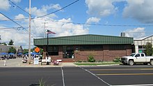
 U.S. Post Office in Harrison
 -
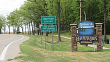 Signage along Bus. US 127 / M-61
 -
 Harrison City Hall
 -
 Harrison Fire Department
 -
 Harrison District Library
 -
 William Henry Wilson House


.jpg)
References
- ^ a b "2020 U.S. Gazetteer Files". United States Census Bureau. Retrieved May 21, 2022.
- ^ a b "U.S. Census website". United States Census Bureau. Retrieved 2008-01-31.
- ^ U.S. Geological Survey Geographic Names Information System: Harrison, Michigan
- ^ "Find a County". National Association of Counties. Retrieved 2011-06-07.
- ^ ISBN 978-0-8143-1838-6.
- ^ "Census of Population and Housing". Census.gov. Retrieved June 4, 2015.
- ^ "U.S. Census website". United States Census Bureau. Retrieved 2012-11-25.
- ^ Michigan Geographic Framework (15 November 2013). "Clare County School Districts" (PDF). Retrieved December 28, 2022.
External links
 | ||||
Village | ||||
| Civil townships | ||||
| Unincorporated communities |
| |||
| Ghost town |
| |||
| Footnotes | ‡This populated place also has portions in an adjacent county or counties | |||
| ||||
| International | |
|---|---|
| National | |
| Geographic | |