
File:MaharashtraVidarbha.png
No higher resolution available.
MaharashtraVidarbha.png (200 × 161 pixels, file size: 7 KB, MIME type: image/png)
| This is a file from the Wikimedia Commons. Information from its description page there is shown below. Commons is a freely licensed media file repository. You can help. |
Summary
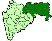
| Description | Districts of the Vidarbha region of Maharashtra. Based on the district maps series created by Nichalp and released by him into the public domain. QuartierLatin1968 21:35, 23 October 2005 (UTC) |
| Date | 23 October 2005 (original upload date) |
| Source | No machine-readable source provided. Own work assumed (based on copyright claims). |
| Author | No machine-readable author provided. QuartierLatin1968 assumed (based on copyright claims). |
Licensing
| I, the copyright holder of this work, release this work into the public domain. This applies worldwide. In some countries this may not be legally possible; if so: I grant anyone the right to use this work for any purpose, without any conditions, unless such conditions are required by law. |
File history
Click on a date/time to view the file as it appeared at that time.
| Date/Time | Thumbnail | Dimensions | User | Comment | |
|---|---|---|---|---|---|
| current | 21:35, 23 October 2005 | | 200 × 161 (7 KB) | QuartierLatin1968 | Districts of the Vidarbha region of Maharashtra. Based on the district maps series created by Nichalp and released by him into the public domain. ~~~~ Category:Maharashtra [[Category:Maps of |
File usage
The following pages on the English Wikipedia use this file (pages on other projects are not listed):
Global file usage
The following other wikis use this file:
- Usage on en.wiktionary.org
- Usage on mr.wikipedia.org
- Usage on ru.wikipedia.org
- Usage on sv.wikipedia.org