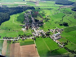
Flaxweiler
This article needs additional citations for verification. (February 2013) |
Flaxweiler
Fluessweiler | ||
|---|---|---|
 | ||
|
Grevenmacher | ||
| Area | ||
| • Total | 30.17 km2 (11.65 sq mi) | |
| • Rank | 26th of 100 | |
| Highest elevation | 387 m (1,270 ft) | |
| • Rank | 63rd of 100 | |
| Lowest elevation | 208 m (682 ft) | |
| • Rank | 28th of 100 | |
| Population (2023) | ||
| • Total | 2,193 | |
| • Rank | LAU 2 LU0001103 | |
| Website | flaxweiler.lu | |
Flaxweiler (
Grevenmacher
.
As of 2024[update], the town of Flaxweiler, which lies in the north-west of the commune, has a population of 593.[1] Other towns within the commune include Beyren, Gostingen, Niederdonven, and Oberdonven.
Population
Graphs are unavailable due to technical issues. There is more info on Phabricator and on MediaWiki.org. |
List of former mayors
| Name | Start | End |
|---|---|---|
| Michel Metzdorf | 1806 | 1810 |
| Pierre Stemper | 1810 | 1812 |
| Jean Nielles | 1813 | 1816 |
| François Strasser | 1816 | 1819 |
| Jean Huberty | 1819 | 1825 |
| Jean Peters (first time) | 1825 | 1830 |
| Michel Pettinger (first time) | 1830 | 1839 |
| Jean Peters (second time) | 1840 | 1848 |
| Michel Pettinger (second time) | 1848 | 1854 |
| Jean-Pierre Huberty | 1854 | 1867 |
| Michel Engel | 1867 | 1876 |
| Antoine Boss | 1876 | 1887 |
| Adolphe Musquar | 1889 | 1895 |
| Jean Molitor | 1895 | 1928 |
| Michel Schritz | 1929 | 1944[note 1] |
| Jean Sturm | 1945 | 1945 |
| Edouard Steffes | 1946 | 1965 |
| Eugène Kauffmann | 1966 | 1970 |
| Roger Lenert | 1970 | 2005 |
| Théo Weirich | 2005 | present (re-elected 2011)[3] |
Footnotes
- Nazi occupation(1940 - 1944)
References
- ^ "Registre national des personnes physiques RNPP : Population par localité". data.public.lu. 2024-01-07.
- ^ "Population par canton et commune". statistiques.public.lu. Archived from the original on 12 September 2016. Retrieved 11 January 2022.
- ^ "Bestätigung für Théo Weirich" (in German). Luxembourg City, Luxembourg: Lëtzebuerger Journal. 9 October 2011. Retrieved 26 August 2012.[permanent dead link]
External links
 Media related to Flaxweiler at Wikimedia Commons
- (in French) Official website
- "Flaxweiler - Découvrir la commune" (in French). Commune of Flaxweiler. Archived from the original on 7 May 2011. Retrieved 25 August 2012.
