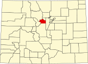
Floyd Hill, Colorado
Appearance
Floyd Hill, Colorado | |
|---|---|
303 & 720 | |
| GNIS feature[2] | Floyd Hill CDP |
Floyd Hill is an
Zip Code 80439) serves the area.[4]
History
Floyd Hill is named after Merril H. Floyd, head of the Clear Creek Wagon Road Company that operated in the 1860s. Mr. Floyd owned a ranch on a hill in the area and the land around the hill, which became known as "Floyd's Hill", where his company built a wagon road over from Idaho Springs to Bergen's ranch.
Geography
The Floyd Hill CDP has an area of 4,027 acres (16.298 km2), including 2.0 acres (0.008 km2) of water.[1]
Demographics
The
United States Census 2010
.
| Year | Pop. | ±% |
|---|---|---|
| 2010 | 998 | — |
| 2020 | 1,048 | +5.0% |
| Source: United States Census Bureau | ||
See also
- Outline of Colorado
- State of Colorado
- Colorado cities and towns
- Colorado census-designated places
- Colorado counties
- Colorado metropolitan areas
- Front Range Urban Corridor
- North Central Colorado Urban Area
- Denver-Aurora-Boulder, CO Combined Statistical Area
- Denver-Aurora-Broomfield, CO Metropolitan Statistical Area
References
- ^ a b c d "State of Colorado Census Designated Places - BAS20 - Data as of January 1, 2020". United States Census Bureau. Retrieved November 4, 2021.
- ^ a b c "U.S. Board on Geographic Names: Domestic Names". United States Geological Survey. Retrieved December 21, 2020.
- ^ "QuickFacts for Colorado". United States Census Bureau. Retrieved October 30, 2021.
- ^ a b "Zip Code 80439 Map and Profile". zipdatamaps.com. 2020. Retrieved December 21, 2020.

