
Fort Allen Park
| Fort Allen Park | |
|---|---|
 | |
| Type | Urban park |
| Location | Portland, Maine, United States |
| Coordinates | 43°39′55″N 70°14′26″W / 43.66536°N 70.24057°W |
| Owned by | City of Portland |
| Open | 24 hours |
Fort Allen Park is an
Havana, Cuba started the Spanish–American War), the foremast and bridge structure of the World War II cruiser USS Portland (CA-33), two Civil War-era 4.5-inch siege rifles, an American Civil War memorial bench erected in 1929,[4] and an historic bandstand which was built in the 1890s. In 2012, a local non-profit group, Friends of the Eastern Promenade, sought to restore Fort Allen Park to its original look.[5]
As of 2016 this has resulted in additional interpretive plaques throughout the park, along with other improvements.
Some sources state that Fort Allen dates from 1775 and was originally named for Revolutionary War hero
Secretary of War's report for 1811.[8] Fort Allen was rebuilt in 1814 with city resources, adding a magazine and barracks due to the British capture of Eastport and Castine in the War of 1812.[9] A plaque at the park states that at this time it was named for Master Commandant William Henry Allen
, a naval officer mortally wounded in the War of 1812.
Gallery
-
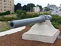 6"/30 caliber gun salvaged from USS Mainein Fort Allen Park
 -
 Mainmast and bridge shield of USS Portland (CA-33)


References
- ^ Murphy, Edward (July 6, 2011). "Fort Allen Park:Reclaiming the high ground". Portland Press Herald. Retrieved April 19, 2013.
- ^ Casco Bay forts at NorthAmericanforts.com
- ^ Fort Allen at FortWiki.com
- ^ "Maine's Civil War Monuments". Retrieved April 19, 2013.
- ^ Koenig, Seth (February 14, 2012). "Fort Allen Park rehabilitation project reaches key stretch". Bangor Daily News. Retrieved April 19, 2013.
- ^ Roberts, pp. 357, 373
- ^ Fort Allen at FortWiki.com
- ^ Wade, p. 241
- ^ Portland forts at NorthAmericanForts.com