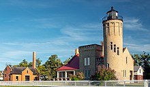
Fort Michilimackinac State Park
This article includes a list of general references, but it lacks sufficient corresponding inline citations. (April 2010) |
| Fort Michilimackinac State Park | |
|---|---|
 View from inside Fort Michilimackinac | |
| Location | Wawatam Township Emmet County, Michigan |
| Nearest city | Mackinaw City, Michigan |
| Coordinates | 45°47′13″N 84°44′08″W / 45.78694°N 84.73556°W |
| Governing body | Michigan Department of Natural Resources |
| www | |
Fort Michilimackinac State Park is a state park in the U.S. state of Michigan. It is located in Mackinaw City along the Straits of Mackinac. The park contains Fort Michilimackinac, which itself is dedicated a National Historic Landmark and Old Mackinac Point Lighthouse as well as the Old Mackinac Point Lighthouse Signal Tower which contains a foghorn.[1]
Colonial Michilimackinac
Colonial
Today, it features re-enactments from British 1770s occupation and the
Fort Michilimackinac
Fort Michilimackinac was an 18th-century French, and later British, fort and trading post in the Great Lakes of North America. Built around 1715, it was located along the southern shore of the strategic Straits of Mackinac connecting Lake Huron and Lake Michigan, at the northern tip of the lower peninsula of the present-day state of Michigan in the United States. The site of the fort in present-day Mackinaw City, Michigan is a National Historic Landmark and is now preserved as an open-air historical museum.[2]
History


This site housed a French fort but that was compromised by the British and became their trading post system, stretching from the Mississippi River through the Illinois Country to the St. Lawrence River. The fort served as a supply for traders in the western Great Lakes.
The French had first established a presence in the Straits of Mackinac in 1671 when Father
The French relinquished the fort, along with their territory in
The British eventually deemed the wooden fort on the mainland too vulnerable to attack, and in 1781 they built Fort Mackinac, a limestone fort on nearby Mackinac Island. Fort Michilimackinac was abandoned after the move.
The fort grounds were designated a National Historic Landmark in 1960. It is a popular tourist attraction as part of Colonial Michilimackinac in
References
- ^ https://www.mackinacparks.com/parks-and-attractions/michilimackinac-state-park/, Michigan’s second state park
- ^ https://www.stateparks.com/fort_michilimackinac_state_park_in_michigan.html, FORT MICHILIMACKINAC STATE PARK - History


