Frays River
| Frays River | |
|---|---|
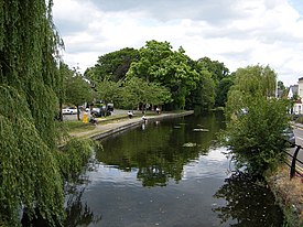
 Frays River in Frays Farm Meadows | |
| Location | |
| Country | England |
| County | Buckinghamshire, London Borough of Hillingdon |
| Physical characteristics | |
| Source | |
| • location | River Colne, Denham Weir, Buckinghamshire |
| • coordinates | 51°33′58″N 0°29′00″W / 51.5661°N 0.4832°W |
| • elevation | 35 m (115 ft) |
| Mouth | |
• location | River Colne, West Drayton |
• coordinates | 51°29′58″N 0°29′05″W / 51.4995°N 0.4848°W |
• elevation | 24 m (79 ft) |
| Length | 5.5 mi (8.9 km) |
| Basin features | |
| Tributaries | |
| • left | River Pinn |
Frays River is a semi-canalised short river in England that branches off the

Course
The Frays River leaves the River Colne east of Denham, Buckinghamshire at Denham Weir. It passes through Frays Farm Meadows, Uxbridge, Cowley, Yiewsley and West Drayton. At Cowley the Grand Union Canal mainline is carried over the river in an aqueduct at Cowley lock. The Frays continues south, flowing past Little Britain Lake on its western side before crossing under the Slough Arm of the Grand Union Canal which is also carried above it in an aqueduct. In Yiewsley it is joined on its east bank by the River Pinn. It then re-joins the River Colne at Drayton Point in West Drayton.

Ecology
The river flows through two
Literary connections
George Orwell once taught at Frays College, Uxbridge, which was on the banks of the river.[5]
See also
References
- ^ "A History of the County of Middlesex Volume 4, Hillingdon, including Uxbridge: Economic and social history". www.british-history.ac.uk. London: Victoria County History. 1971. pp. 75–82. Retrieved 23 December 2020.
- ^ "Frays Farm Meadows". www.wildlondon.org.uk. Retrieved 23 December 2020.
- ^ "Denham Lock Woods". www.wildlondon.org.uk. Retrieved 23 December 2020.
- ^ "Frays Island and Mabey's meadow". www.wildlondon.org.uk. Retrieved 23 December 2020.
- ^ Peter Stansky and William Abrahams The Unknown George Orwell
