
Gare, Luxembourg
Gare
Garer Quartier ( Luxembourgish) | |
|---|---|
 Gare is one of 24 quarters in Luxembourg City | |
| Coordinates: 49°36′06″N 6°07′54″E / 49.6016°N 6.1316°E | |
| Country | Luxembourg |
| Commune | Luxembourg City |
| Area | |
| • Total | 1.0526 km2 (0.4064 sq mi) |
| Population (31 December 2022)[2] | |
| • Total | 11,895 |
| • Density | 11,000/km2 (29,000/sq mi) |
| Nationality | |
| • Luxembourgish | 16.02% |
| • Other | 83.98% |
| Website | Gare |
Gare (
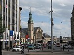
Luxembourg station, around which it subsequently developed.[1] The quarter's name translates into English, from the French Gare, to "station".[1]
Geographically, the quarter is situated on the
Bourbon plateau, and is separated from the Ville Haute quarter, heart of Luxembourg's ancient fortifications, by a steep valley where the Pétrusse joins the Alzette river in the Grund quarter. The valley was first spanned by the Passerelle viaduct, opened in 1859.[1]
Following the 1867 Treaty of London, which ordered the dismantling of Luxembourg's fortifications, the quarter expanded rapidly, notably with the construction of the Adolphe Bridge, opened in 1903, and connected to the station by the grand Avenue de la Liberté.[1]
As of 31 December 2022[update], the quarter has a population of 11,895 inhabitants.[2]
Gallery
-
-
 Villa Clivio
 -
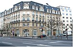 The Hôtel de Paris in Paris Square (Place de Paris)
 -
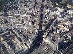 Aerial view of the quarter around Avenue de la Liberté


_2b_(cropped).JPG)
References
External links
![]() Media related to Gare (Luxembourg City) at Wikimedia Commons
Media related to Gare (Luxembourg City) at Wikimedia Commons