
Gauldal
| Gauldalen | |
|---|---|
| Gauldal | |
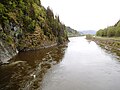
 View of the Gaula River at Kotsøy in Midtre Gauldal | |
 Gauldalen Location of the valley  Gauldalen Gauldalen (Norway) | |
| Length | 145 kilometres (90 mi) |
| Geology | |
| Type | River valley |
| Geography | |
| Location | Trøndelag, Norway |
| Coordinates | 62°58′05″N 10°58′03″E / 62.9681°N 10.9675°E |
| Rivers | Gaula |
Gauldal or Gauldalen (English: Gaula River valley) is a
The traditional district of Gauldal includes the municipalities of Holtålen, Midtre Gauldal, and Melhus. The municipality of Røros is often (traditionally) counted as a part of the district, even though it lies outside the actual Gaula river valley.[1]
History

In September 1345, there was a landslide just north of the village of Støren. The landslide was at a very narrow point in the valley and possibly 45,000,000 cubic metres (59,000,000 cu yd) of gravel and dirt from the mountainside fell and blocked the valley and Gaula river below creating a dam on the river that was possibly 30 to 40 metres (98 to 131 ft) high. This tremendous landslide then created a quickly rising lake that began to flood the valley up to 15 kilometres (9.3 mi) upstream from the dam. This newly formed lake flooded and destroyed 25 upstream farms in the narrow valley. The vast amount of water building up behind the earthen dam from the landslide did not hold long and, when it burst, the water rushed though the dam and caused a major flood downstream, killing about 500 people and destroying another 25 farms as well as several churches. The downstream flash flood continued to just past the village of Melhus, not far from the mouth of the river Gaula. This was one of the worst natural disasters ever in Norway.[2]
Media gallery
-
 Gauldalen valley
 -
 Gauldalen valley
 -
 Gauldalen valley
 -
 Historic farm in the valley
 -
 Gaula river
 -
 Gaula river
 -
 Støren village
 -
 Støren Church
 -
 Melhus village

.jpg)
.jpg)
.jpg)
.jpg)
.jpg)
.JPG)


References
- ^ Store norske leksikon (in Norwegian). Kunnskapsforlaget. Retrieved 2018-01-20.
- .