
Geierhaupt
| Geierhaupt | |
|---|---|
 Geierhaupt | |
| Highest point | |
| Elevation | 2,417 m (7,930 ft) |
| Prominence | 1,172 m (3,845 ft)[1] |
| Isolation | 18.9 km (11.7 mi) |
| Coordinates | 47°22′N 14°38′E / 47.367°N 14.633°E |
| Geography | |
 Geierhaupt Location in the Alps | |
| Location | Styria, Austria |
| Parent range | Lower Tauern |
Geierhaupt (2,417 m) is a mountain of the Lower Tauern in Styria, Austria. It is the highest mountain of the Seckau Tauern sub group. [2]
Pictures
-
 Geierhaupt West Face (from Kettentalkogel)
 -
 Geierhaupt South-East Face (from Höllkogel)
 -
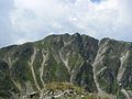
 Hölltal with Geierhaupt above (from Weißsattel)
 -
 Summit of Mt. Geierhaupt


References
- ^ "Geierhaupt - peakbagger". peakbagger.com. Retrieved 2 March 2015.
- ^ "Niedere Tauern - summitpost". summitpost.org. Retrieved 2 March 2015.
This Styria location article is a stub. You can help Wikipedia by expanding it. |