
Gillespie Dam
| Gillespie Dam | |
|---|---|
 The Gila River flows freely through the breached dam. | |
| Official name | Gillespie Dam |
| Location | Maricopa County, Arizona, US |
| Coordinates | 33°13′45″N 112°46′10″W / 33.22917°N 112.76944°W |
| Purpose | Irrigation |
| Status | Decommissioned |
| Opening date | 1921[1] |
| Demolition date | 1993 |
| Dam and spillways | |
| Type of dam | Gravity dam |
| Impounds | Gila River |
| Height | 80 feet (24 m) |
| Length | 1,700 feet (520 m) |
| Reservoir | |
| Creates | Gillespie Dam Reservoir (former) |
The Gillespie Dam is a concrete gravity dam located on the Gila River between the towns of Buckeye and Gila Bend, Arizona. The dam was constructed during the 1920s for primarily irrigation purposes. It was key to the development of a 72,000-acre (29,000 ha) parcel owned by "millionaire" W.S. Gillespie of Tulsa, Oklahoma, initially allowing for irrigation of 10,000 acres (4,000 ha).[2] A portion of the dam failed unexpectedly in 1993 during unusually heavy rains.
History
The Gillespie Dam was constructed circa 1920 by a local rancher, Frank Gillespie (Gillespie Land and Irrigation Company),[3] to replace an existing structure.[4][5] As the dam was located at an important river crossing that would later become U.S. Route 80, the Arizona Highway Department – the predecessor to the Arizona Department of Transportation – constructed a concrete apron at the foot of the dam to allow for vehicular crossings. As the dam was a simple spillover construction, during times of heavy runoff cars would have to be pulled through the flow by trucks, and during floods could not cross at all.[1]
In anticipation of the formation of the
Townsite
The dam was also to have supported a new town of Gillespie that was to be built 12 miles (19 km) west of
Failure
The winter months of 1993 saw unusually high rainfall amounts that resulted in record flows through central Arizona rivers and streams, including the Salt River, a major tributary to the Gila upstream from the Gillespie Dam.[7] At approximately 10:30 on the morning of January 9, the dam failed when a segment approximately 120 feet (37 m) in length collapsed into the river. While the precise cause of the failure is unknown, the extreme flooding was almost certainly a contributing factor. The precise size of the flood was not recorded due to equipment failure, but an estimate based upon a high-water mark recorded on USGS equipment yielded a peak flow of approximately 200,000 cubic feet (5,700 m3) per second, corresponding to a predicted 65-year flood, or a flood of a magnitude anticipated only once per 65 years. The previous high, recorded during similarly disastrous floods in 1980, had been 178,000 cubic feet (5,000 m3) per second.[8]
Due to the failure, three underground natural gas lines were exposed and later severed by the floodwaters. The bridge downstream survived, and was deemed safe for travel.[1]
The remnants of the dam remain in place and the area is largely accessible to the public. A small earthen embankment exists to divert water into nearby canals.
Gallery
-
 Ruins of the dam
 -
 The ruins of the dam
 -
 Different view of the dam
 -
 The Gillespie Dam
 -
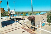 Rusted equipment on the dam
 -
 More rusted equipment on the dam


-
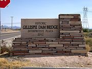 The historic Gillespie Dam Bridge marker
 -
 The historic Gillespie Dam Bridge
 -
 Front view of the bridge
 -
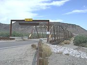 Different view of the bridge


References
- ^ a b c d "Historic Gillespie Dam". Town of Gila Bend. Retrieved 2008-06-03. [dead link]
- ^ The Copper Era. May 20, 1919. p. 5. Retrieved September 25, 2022 – via The Arizona Memory Project.
- Newspapers.com.

- ^ "Field Excursion Reports". United Nations University. Retrieved 2008-06-03.
- ^ "Feature Detail Report for: Gillespie". Geographic Names Information System. United States Geological Survey, United States Department of the Interior.
- ^ "Gillespie Dam Bridge". Arizona State Parks. Archived from the original on May 26, 2006. Retrieved 2008-06-03.
- ^ "Arizona's Most Notable Storms". National Weather Service. Retrieved 2008-06-03.
- ^ Larson, Robert; James Slosson (1997). Storm-induced Geologic Hazards: Case Histories from the 1992–1993 Winter. Geological Society of America. pp. 32–33.
Crossings of the Gila River | ||||
|---|---|---|---|---|
| ||||
| Authority control databases: National |
|---|