
Gmina Rząśnia
Gmina Rząśnia
Rząśnia Commune | |
|---|---|
 Flag  Coat of arms | |
| Coordinates (Rząśnia): 51°13′15″N 19°2′28″E / 51.22083°N 19.04111°E | |
| Country | |
| Voivodeship | Łódź |
| County | Pajęczno |
| Seat | Rząśnia |
| Area | |
| • Total | 86.37 km2 (33.35 sq mi) |
| Population (2006) | |
| • Total | 4,802 |
| • Density | 56/km2 (140/sq mi) |
| Website | http://www.rzasnia.pl/ |
Gmina Rząśnia is a rural gmina (administrative district) in Pajęczno County, Łódź Voivodeship, in central Poland. Its seat is the village of Rząśnia, which lies approximately 9 kilometres (6 mi) north of Pajęczno and 70 km (43 mi) south-west of the regional capital Łódź.
The gmina covers an area of 86.37 square kilometres (33.3 sq mi), and as of 2006 its total population is 4,802.
In the municipality of Rząśnia, there is a brown Coal Mine
-
 Coal Mine Bełchatów
 -
 Church in Stróża
 -
 Church in Rząśnia
 -
 Railway station in Biała
 -
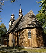
 Church in Kodrań


Villages
Gmina Rząśnia contains the villages and settlements of Augustów, Będków, Biała, Broszęcin, Broszęcin-Kolonia, Gawłów, Kodrań, Krysiaki, Marcelin, Rekle, Rychłowiec, Rząśnia, Ścięgna, Stróża, Suchowola, Suchowola-Majątek, Zabrzezie, Żary and Zielęcin.
Neighbouring gminas
Gmina Rząśnia is bordered by the gminas of Kiełczygłów, Pajęczno, Rusiec, Strzelce Wielkie, Sulmierzyce and Szczerców.
References
| Seat | ||
|---|---|---|
| Other villages | ||
Seat: Pajęczno | ||
| Urban-rural gminas |  | |
| Rural gminas | ||