
Golica
| Golica | |
|---|---|
 Golica | |
| Highest point | |
| Elevation | 1,835 m (6,020 ft) |
| Coordinates | 46°29′24″N 14°03′01″E / 46.49000°N 14.05028°E[1] |
| Geography | |
| Parent range | Karawanks |

Golica (1835 m) (
Carinthia; the Ljubljana Basin
can be seen from the summit on clear days.
Golica also gained considerable fame as the subject of the 1955 Slavko Avsenik polka Na Golici (On Golica), the Avsenik Ensemble's most popular song. Despite having given the song this title, Avsenik was never in his life on Golica.[3]
250 m below the summit, there is a
The slopes of Golica are today used as pastures for sheep, but until 1957 locals from settlements at its foot would clear the entire slope of grass for hay (a possible etymology of the name, which derives from the adjective "gol-," or "bare.").
The best way to reach the peak is from
Jesenice via the mountain village of Planina pod Golico
, which bears the peak's name.
Gallery
-
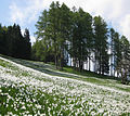 Narcissi fields under Golica
 -
 Golica mountain hut


References
- ^ Golica on Geopedia
- ^ Slovenian Tourist Board website
- ^ Nikoli nisem bil na Golici (I was never on Golica) - slovene - access 30 Jan 2010
- ^ Jesenice Mountaineering Association website
External links
- Information about Golica on Hribi.net
 Media related to Golica at Wikimedia Commons
|  | ||||||
|---|---|---|---|---|---|---|---|
| Landmarks | |||||||
| Places of worship | |||||||
| Notable people | |||||||