
Gourin
Gourin | |
|---|---|
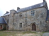
 The Manor of Tronjoly | |
.svg) Coat of arms | |
Location of Gourin  | |
 Gourin  Gourin | |
| Coordinates: 48°08′28″N 3°36′21″W / 48.1411°N 3.6058°W | |
| Country | France |
| Region | Brittany |
| Department | Morbihan |
| Arrondissement | Pontivy |
| Canton | Gourin |
| Intercommunality | Roi Morvan Communauté |
| Government | |
| • Mayor (2020–2026) | Hervé Le Floc'h[1] |
| Area 1 | 74.72 km2 (28.85 sq mi) |
| Population (2021)[2] | 3,823 |
| • Density | 51/km2 (130/sq mi) |
| Time zone | UTC+01:00 (CET) |
| • Summer (DST) | UTC+02:00 (CEST) |
| INSEE/Postal code | 56066 /56110 |
| Elevation | 83–301 m (272–988 ft) |
| 1 French Land Register data, which excludes lakes, ponds, glaciers > 1 km2 (0.386 sq mi or 247 acres) and river estuaries. | |
Gourin (French pronunciation: [ɡuʁɛ̃]; Breton: Gourin) is a commune in the Morbihan département of Brittany in north-western France.[3]
Geography
Gourin is in the northwest of Morbihan, 40 km (25 mi) northeast of Quimper and 47 km (29 mi) northwest of Lorient. Historically, it belongs to Cornouaille. Gourin is on the southern slope of the Montagnes Noires (French, Black Mountains). The river Inam rises in the northern part of Gourin and flows to the south.
Map

Demographics
Inhabitants of Gourin are called in French Gourinois. Gourin lost 40% of its population since 1946.
|
| ||||||||||||||||||||||||||||||||||||||||||||||||||||||||||||||||||||||||||||||||||||||||||||||||||||||||||||||||||
| |||||||||||||||||||||||||||||||||||||||||||||||||||||||||||||||||||||||||||||||||||||||||||||||||||||||||||||||||||
| Source: EHESS[4] and INSEE (1968-2020)[5] | |||||||||||||||||||||||||||||||||||||||||||||||||||||||||||||||||||||||||||||||||||||||||||||||||||||||||||||||||||
History
This small town is well known for the
Gourin still has a large number of native Breton speakers. The people of this region are very proud of their Celtic heritage and have preserved many old customs and traditions.

Breton language
In 2008, 18.32% of primary school children attended bilingual schools.[6]
People
- Georges Cochevelou, father of the Breton musician, Alan Stivell, was from Gourin
Twinning
Gourin is
Gallery
-
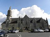 The parish church
 -
-
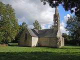
 Sainte-Julienne chapel
 -
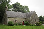
 Manor of Kerbiquet
 -
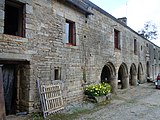
 Manor of Menguionnet
_%C3%89glise_01.JPG)


See also
- Communes of the Morbihan department
- Listing of the works of the atelier of the Maître de Tronoën
- List of the works of the Maître de Lanrivain
References
- ^ "Maires du Morbihan" (PDF). Préfecture du Morbihan. 7 July 2020.
- ^ "Populations légales 2021". The National Institute of Statistics and Economic Studies. 28 December 2023.
- ^ INSEE commune file
- ^ Des villages de Cassini aux communes d'aujourd'hui: Commune data sheet Gourin, EHESS (in French).
- ^ Population en historique depuis 1968, INSEE
- ^ (in French) Ofis ar Brezhoneg: Enseignement bilingue
External links
- Official website
- Base Mérimée: Search for heritage in the commune, Ministère français de la Culture. (in French)
- art movies Gourin (in French)
- English guide to Gourin (in English)
- Mayors of Morbihan Association (in French)
| International | |
|---|---|
| National | |
| Geographic | |
This Morbihan geographical article is a stub. You can help Wikipedia by expanding it. |