
Grand Port District
Grand Port District | |
|---|---|
UTC+4 (MUT) | |
| ISO 3166 code | MU-GP (Grand Port) |
Grand Port (Mauritian Creole pronunciation: [ɡʁɑ̃ poː]) is a district of Mauritius, situated in the east of the island. The name means "large port" in French. The district has an area of 260.3 km2 and the estimated population was 112,997, as of 31 December 2015.[2]
History
This section needs expansion. You can help by adding to it. (September 2012) |
Grand Port is named after the village of 'Old Grand Port' which saw the first Dutch landing and the first port of the island. It is centered on the town of Mahébourg on the coast, inside the Grand Port Bay. Built by the Dutch and later taken over by the French, the town is a reminder of the colonial past of the island.
In 1810, a French squadron of
Places of interest
This section needs expansion. You can help by adding to it. (September 2012) |
The district's most well known and popular beach is Blue Bay, one of the finest bathing spots on the island surrounded by a semicircle of filao trees. Situated on the southeast coast, not far from Mahébourg, Blue Bay offers a fine stretch of white sandy beach, and a deep, clear, light-blue bathing pool. There is also scope for yachting and windsurfing. Many structures in the district reflect the colonial past of the district.
Just north of Mahebourg,
Places
The Grand Port District include different regions; however, some regions are further divided into different suburbs.
.jpg)
Places by population
| Places by population, area and density | ||||||||
|---|---|---|---|---|---|---|---|---|
| Place | Population[5] | Area in km2[6] | Population density per km2[6] | |||||
| Bambous Virieux | 1,496 | 7.7 | 194.5 | |||||
| Bananes | 660 | 10.08 | 65.5 | |||||
| Beau-Vallon, Mauritius | 6,904 | 10.13 | 681.5 | |||||
| Bois des Amourettes | 1,880 | 6.52 | 220.7 | |||||
| Cluny | 1,549 | 11.18 | 138.6 | |||||
| Grand Bel Air | 1,538 | 2.8 | 549.3 | |||||
| Grand Sable | 2,182 | 5.02 | 434.7 | |||||
Savanne district ) |
7,770 | 12.18 | 637.9 | |||||
| Mahébourg | 15,176 | 2.24 | 6,775 | |||||
| Mare Chicose | 325 | 15.63 | 20.8 | |||||
| Mare d'Albert | 4,666 | 4.62 | 1,010 | |||||
| Mare Tabac | 2,731 | 11.09 | 246.3 | |||||
New Grove |
10,518 | 5.55 | 1,895.1 | |||||
Nouvelle France |
7,165 | 15.92 | 450.1 | |||||
| Vieux Grand Port | 2,969 | 31.72 | 93.6 | |||||
| Petit Bel Air | 1,186 | 1.47 | 806.8 | |||||
| Plaine Magnien | 10,443 | 13.99 | 746.5 | |||||
| Rivière des Créoles | 3,066 | 6.2 | 494.5 | |||||
Savanne district ) |
1,281 | 3.32 | 385.4 | |||||
Rose Belle |
12,035 | 9.13 | 1,318.2 | |||||
Saint Hubert |
3,153 | 35.47 | 88.9 | |||||
| Trois Boutiques (Union Vale) | 7,322 | 36.87 | 198.6 | |||||
| Union Park | 4,907 | 6.55 | 749.2 | |||||
Gallery
-
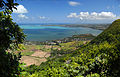 Grand Port seen from high ground.
 -
 Grand Port on a 1950 stamp of Mauritius.
.jpg)

See also
References
- ^ "Archived copy". Archived from the original on 4 April 2014. Retrieved 20 October 2013.
{{cite web}}: CS1 maint: archived copy as title (link) - ^ a b c Ministry of Finance & Economic Development (2016). "ANNUAL DIGEST OF STATISTICS 2015" (PDF). August. Government of Mauritius: 19. Archived (PDF) from the original on 1 December 2018. Retrieved 23 December 2016.
{{cite journal}}: Cite journal requires|journal=(help) - ^ Statistic office of Mauritius (2011). "Housing and population Census 2011" (PDF). Government of Mauritius. Archived from the original (PDF) on 21 October 2013. Retrieved 6 September 2012.
{{cite journal}}: Cite journal requires|journal=(help) - ^ "MUNICIPALES: Toilettage des registres d'électeurs | le Mauricien". Archived from the original on 14 July 2014. Retrieved 11 July 2014.
- ^ "Table D2 - Resident population by geographical location, age and sex" (PDF). 2011 housing and population census. Statistics Mauritius. p. 51. Archived from the original (PDF) on 16 October 2013..
- ^ a b "Non-Existent Domain" (PDF). Archived from the original (PDF) on 3 March 2016. Retrieved 19 September 2016.