
Great Alne
| Great Alne | ||
|---|---|---|
Shire county | ||
| Region | ||
| Country | England | |
| Sovereign state | United Kingdom | |
| Post town | Alcester | |
| Postcode district | B49 | |
| Dialling code | 01789 | |
| Police | Warwickshire | |
| Fire | Warwickshire | |
| Ambulance | West Midlands | |
| UK Parliament | ||
| Website | www | |
Great Alne is a small village in
History
Land at Alne was given by
It has since passed through a number of private hands, being owned by different local families including the Throckmortons and Holyoakes.[4] Alne Mill, converted into luxury flats in 1989, lies about 0.25 miles (0.40 km) to the south of the village and the road leading down to it is probably the Milnewey or Millway mentioned in 1541 and 1728. The mill at Alne, which was worth 5s. in the Domesday Book, and had increased in value to 6s. 8d. in the Taxation of 1291. In 1516 it was let by the abbot to John and Elizabeth Palmer at an annual rent of £1 10s.[4]
Governance
Great Alne is in the
Notable buildings

The
The
There is one pub-restaurant, The Huff Cap,[11] formerly the Mother Huff Cap Inn, the name deriving from the days when most pubs brewed their own beer, Huff Cap being a 16th-century term for a strong ale that would ‘huf one’s cap’ or make the head swell, not for the froth on the top of the beer as is sometimes stated.[12] The 'mother' is likely to be the dame who brewed the beer and managed the public house. In 1746 the pub is thought to have been 'The Huff Cap' and to have acquired 'mother' later. This hostelry was once on the main coach road from Stratford to Bridgnorth.[13]
Transport
The old railway station, built on the Great Western Railway branch-line from Bearley to Alcester opened in 1876[4] but is now converted to a residential dwelling. The station sat on the GWR's Alcester Branch linking their Hatton – Stratford-upon-Avon Branch with the now defunct Midland Railway's Gloucester Loop line South of Redditch. The line closed to passengers in 1917 only to reopen between 1922/3 but stopping again in 1939 for passenger use, apart from workers' trains to the nearby Maudslay Motor Company's works from Birmingham. The line closed completely in 1951 with lifting of the track taking place shortly afterwards.[14]
Education
Great Alne
| School | Compulsory education stage | School website | Ofsted details
|
|---|---|---|---|
| Great Alne Primary School | Primary | Great Alne Primary School | Ofsted details for unique reference number 125511 |
Gallery
-
 Interior of the church
 -
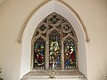 East Window depicting biblical scenes from the life of Mary Magdalene
 -
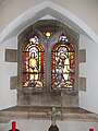 Stained Glass North Aisle
 -
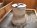 The Font
 -
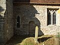 Exterior stone work
 -
 War Memorial


References
- ^ "Civil Parish population 2011". Neighbourhood Statistics. Office for National Statistics. Retrieved 22 December 2015.
- ^ Great Alne Parish Council: "near to the river which our ancestors used to call, and which is called to this day, Alwine." The Celtic word Alwine meaning bright or clear.
- ^ Great Alne Parish Council
- ^ a b c d e A History of the County of Warwick: Volume 3: Barlichway hundred (1945), pp. 86–88. URL: http://www.british-history.ac.uk/report.aspx?compid=56975
- ISBN 0-85033-141-2
- ^ Antiquities of Warwickshire, William Dugdale, 1656
- ^ Stratford District Council website
- ISBN 0-14-071031-0
- ^ Survei of the Ministrie in Warwickshier 1586
- ^ https://archive.org/stream/publicationsdugd10dugduoft/publicationsdugd10dugduoft_djvu.txt [dead link]
- ^ "The Huff Cap, Pubs Great Alne, Pubs Warwickshire, Pubs B49 6HY". Archived from the original on 30 May 2011. Retrieved 8 June 2011.
- ISBN 1-85326-334-6
- ^ Richard Churchley, Local Past, Autumn 1981
- ^ "Great Alne Station".
External links
- Alne in the Domesday Book
