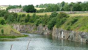
Greenfoot Quarry
| Greenfoot Quarry | |
|---|---|
 Greenfoot Quarry | |
| Location | MAGiC MaP |
| Nearest town | Stanhope |
| Coordinates | 54°44′54″N 2°1′43″W / 54.74833°N 2.02861°W |
| Area | 0.9 ha (2.2 acres) |
| Established | 1984 |
| Governing body | Natural England |
| Website | Greenfoot Quarry SSSI |
Greenfoot Quarry is a Site of Special Scientific Interest in the Wear Valley district of west County Durham, England. It is a disused quarry, situated in the Wear valley, 1 km upstream from the village of Stanhope.
The site has
intrusion
.
[1]
References
- ^ "Greenfoot Quarry : Reasons for SSSI status" (PDF). Natural England. Retrieved 1 April 2022.

