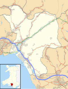
Gwaun-Cae-Gurwen
Gwaun-Cae-Gurwen
| |
|---|---|
 | |
Location within Neath Port Talbot | |
| Population | 4,240 (2011)[1] |
| OS grid reference | SN705115 |
| Principal area | |
| Preserved county | |
| Country | Wales |
| Sovereign state | United Kingdom |
| Post town | AMMANFORD |
| Postcode district | SA18 |
| Dialling code | 01269 |
| Police | South Wales |
| Fire | Mid and West Wales |
| Ambulance | Welsh |
| UK Parliament | |
| Senedd Cymru – Welsh Parliament | |
Gwaun-Cae-Gurwen (Welsh: Gwauncaegurwen) is a village and community in Neath Port Talbot, South West Wales. Historically a part of Glamorgan, Gwaun-Cae-Gurwen is a parish made up of the electoral wards of Gwaun-Cae-Gurwen and Lower Brynamman.
Location
Gwaun-Cae-Gurwen is located five miles east of the nearest town of Ammanford and nearly fifteen miles north of Swansea. Nearby villages include Cwmgors, Lower Brynaman & Tairgwaith.
Etymology
The name Gwaun-Cae-Gurwen is believed to be an alteration of what was originally gwaun cegerwen (i.e. "white hemlock heath" in Welsh, ceger being a dialect form of cegid).[2] In local usage, the name is often shortened to "Y Waun", meaning "the heath" in Welsh.
History
Gwaun-cae-Gurwen was a mining village in the west Wales anthracite district. There were six or seven pits in the early 1920s.[3]
Schools
Ysgol Gynradd Gymraeg Gwauncaegurwen (Gwaun-cae-Gurwen Welsh
Secondary-age children in the area have the choice of going to Ysgol Gyfun Ystalyfera in Ystalyfera (for full Welsh-medium education),[4] Ysgol Dyffryn Aman (for Welsh- and English-medium education),[5] or Cwmtawe Community School (for English-medium education).[6]
Welsh language
The Welsh Language Board reported in 2009 that 67.9% of the population of Gwaun-Cae-Gurwen can speak, read or write in Welsh. 10–19 year olds were the group with the highest percentage of Welsh speakers.[7]
Representation
The area is represented in the
The electoral ward mentioned above has a population taken at the 2011 census of 2,910.[8]
Sport
Cwmgors RFC play their home games at Parc-y-werin, Gwaun-Cae-Gurwen. Their clubhouse is also situated at New Road, Gwaun-Cae-Gurwen.
Notable natives
- Sir British and Irish Lionsplayer; a street, Maes Gareth Edwards, is named after him
- Dame Siân Phillips, actress
- Barry Morgan, Archbishop of Wales and Bishop of Llandaff
- Gwenda Thomas, former member of the Senedd and Deputy Minister in the Welsh Government
Pwll-y-Wrach
At one time, almost all of the land of The Waun was owned by the Jones Family who also owned the "Pwll-y-Wrach Estate". It was run by the Head and later by their sons (and spouses). They still own parts of the land of the village but most has been sold off. Both farmhouses connected to the Estate are still standing. They are: Pwll-y-Wrach and Glangwrach. Pwll-y-Wrach is the main house where the head of the family lived.
It is no longer a farming estate but continues to own much of the land in the village. The name means the Witch's Pool in English, because of an old
References
- ^ "Community population 2011". Retrieved 12 April 2015.
- ^ "Cwmgors a'r Waun local history website". Archived from the original on 18 September 2006. Retrieved 17 September 2006.
- ISBN 978-0-7524-4793-3. (Page 128)
- ^ Ysgol Gyfun Ystalyfera website
- ^ Ysgol Dyffryn Aman website
- ^ Ysgol Gymunedol Cwmtawe website
- ^ Bwrdd yr Iaith Gymraeg / Welsh Language Board Archived 2011-10-04 at the Wayback Machine
- ^ "Ward population 2011". Retrieved 12 April 2015.

