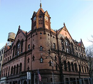
Harlem Courthouse
Harlem Courthouse | |
New York City Landmark No. 0297
| |
 (2009) | |
 | |
| Location | 170 East 121st Street Manhattan, New York City |
|---|---|
| Coordinates | 40°48′4.5″N 73°56′18.5″W / 40.801250°N 73.938472°W |
| Built | 1891-93[2][3] |
| Architect | Thom & Wilson |
| Architectural style | Romanesque Revival |
| NRHP reference No. | 80002692[1] |
| NYCL No. | 0297 |
| Significant dates | |
| Added to NRHP | April 16, 1980 |
| Designated NYCL | August 2, 1967 |
The Harlem Courthouse at 170 East 121st Street on the corner of Sylvan Place – a remnant of the former
terra cotta building features gables
, archways, an octagonal corner tower and a two-faced clock. It was built for the Police and District Courts, but is now used by other city agencies.
In 1936, during the New Deal, Federal Art Project artist David Karfunkle painted a mural, "Exploitation of Labor and Hoarding of Wealth" on its third floor.[5][6][7]
The city government used the building as a laboratory to measure air pollution. At the time of the 1966 New York City smog, it was the city's only station to measure the air.[8]
The building was designated a
New York City landmark in 1967, and was added to the National Register of Historic Places
in 1980.
See also
- National Register of Historic Places listings in Manhattan above 110th Street
- List of New York City Designated Landmarks in Manhattan above 110th Street
References
Notes
- ^ "National Register Information System". National Register of Historic Places. National Park Service. March 13, 2009.
- ISBN 978-0-19538-386-7.
- ISBN 978-0-470-28963-1.
- ISBN 0-231-12543-7., p. 61
- ^ "CultureNOW - Exploitation of Labor and Hoarding of Wealth: David Karfunkle".
- ^ "Harlem Court House". Harlem One Stop.
- ^ "Harlem Court House". Archived from the original on 2011-12-11. Retrieved 2011-12-29.
- ^ Schumach, Murray (November 27, 1966). "Smog Swept Away By Cool Air Mass". The New York Times.
External links
 Media related to Harlem Courthouse at Wikimedia Commons


