
Hateruma Airport
Hateruma Airport 波照間空港 Hateruma Kūkō | |||||||||||
|---|---|---|---|---|---|---|---|---|---|---|---|
AMSL 43 ft / 13 m | | ||||||||||
| Coordinates | 24°03′30″N 123°48′14″E / 24.05833°N 123.80389°E | ||||||||||
| Map | |||||||||||
 RORH Location in Japan  RORH RORH (Japan) | |||||||||||
| Runways | |||||||||||
| |||||||||||
Hateruma Airport (波照間空港, Hateruma Kūkō) (
Yaeyama District, Okinawa Prefecture, Japan. The prefecture operates the airport, which is classified as a third class airport
.
Gallery
-
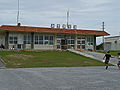 Hateruma Airport before rebuilding
 -
![A Ryukyu Air Commuter counter at Hateruma; as of 2008 Ryukyu Air Commuter no longer serves Hateruma[2]](//upload.wikimedia.org/wikipedia/commons/thumb/3/33/RyukyuAirCommuterCounterHaterumaAirport.JPG/120px-RyukyuAirCommuterCounterHaterumaAirport.JPG) A Ryukyu Air Commuter counter at Hateruma; as of 2008 Ryukyu Air Commuter no longer serves Hateruma[2]
A Ryukyu Air Commuter counter at Hateruma; as of 2008 Ryukyu Air Commuter no longer serves Hateruma[2]

![A Ryukyu Air Commuter counter at Hateruma; as of 2008 Ryukyu Air Commuter no longer serves Hateruma[2]](/File:RyukyuAirCommuterCounterHaterumaAirport.JPG)
References
- ^ AIS Japan
- ^ "Hateruma Airport Guide at Japan Airlines. Retrieved on February 1, 2008.[dead link]
External links
- Hateruma Airport
- Accident history for HTR at Aviation Safety Network
This article about a Japanese airport is a stub. You can help Wikipedia by expanding it. |
This Okinawa Prefecture location article is a stub. You can help Wikipedia by expanding it. |