
High Rocks
Notification 1986[1] | | |
| Location map | Magic Map | |
|---|---|---|
High Rocks is a 3.2-hectare (7.9-acre) geological
Prehistory
The location was formed when a melting ice sheet at the end of the last
Recent history
After King James II visited Tunbridge Wells and made the woodland a resort in the 17th century, High Rocks became a tourist attraction which also offered a maze, a bowling green, gambling rooms and cold baths. The Aerial Walk, a series of bridges linking the tops of the crags, was built in the 19th century.
A halt served by the local railway was established in 1907, and was used until 1952. The
Geology and geomorphology
High Rocks is a key
Open gulls are comparatively rare in Britain, except in the central Weald, and they are nowhere better revealed than in the numerous open passages at High Rocks. The Ardingly Sandstone is friable and poorly cemented, but the surface develops a protective crust and displays a variety of micro-weathering features, notably honeycombing and polygonal cracking. The origin of this cracking is problematic but may relate to freezing and thawing under periglacial conditions during the Pleistocene. This type of cracking is found in Britain only on the sandstone outcrops in the central Weald, and is most strikingly displayed at High Rocks.
-
 Steps leading up to the Aerial Walk.
 -
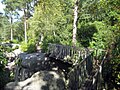
 The large chasm and one of the bridges.
 -
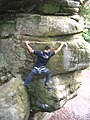 A rock climber scaling a sandstone crag.
 -
 The Crooked Bridge of the Aerial Walk.


Current use
The crags are visited by rock climbers and other members of the public. It is also frequently used for wedding receptions. Footpaths lead around the rocks, and it is possible to walk across the top of crags on footbridges. The main area is fenced in and there is a £6 entrance fee (£3 for children) to enter the site.[5]
An unfenced and free access section of the ridge of rock outcrops can be reached by following the public footpath east of the pub, next to the railway bridge.
References
- ^ a b c d "Designated Sites View: High Rocks". Sites of Special Scientific Interest. Natural England. Retrieved 8 February 2018.
- ^ "Map of High Rocks". Sites of Special Scientific Interest. Natural England. Retrieved 8 February 2018.
- ^ "High Rocks (Quaternary of South-East England)". Geological Conservation Review. Joint Nature Conservation Committee. Retrieved 11 January 2018.
- ^ "High Rocks, Tunbridge Wells History". Penshurst Online. Retrieved 27 December 2011.
- ^ "High Rocks National Monument" (PDF). The High Rocks. Archived from the original (PDF) on 3 September 2013. Retrieved 5 February 2013.