
Hochsimmer
| Hochsimmer | |
|---|---|
Eastern High Eifel) | |
| Geology | |
| Mountain type | Cinder cone |
| Type of rock | Basalt |
Bell
) looking west-southwest to the Hochsimmerviewing tower
)The Hochsimmer is a
Rhineland-Palatine county of Mayen-Koblenz. At the summit is an observation tower, the Hochsimmer Tower
.
Geography
Location
The Hochsimmer rises within the
St. Johann
.
Height and summits
The Hochsimmer has two domed summits or kuppen: the West Top (West Top 50°21′38.5″N 7°11′54.8″E / 50.360694°N 7.198556°E) is 587.9 m high and the East Top (East Top 50°21′36.3″N 7°12′9.1″E / 50.360083°N 7.202528°E) is 583.3 m high. About 600 metres southwest of the summit is the Kleiner Simmer (514.7 m).[1]
Towers
On the east top of the Hochsimmer stands the 18-metre-high
Eastern High Eifel, the Middle Rhine Basin and of Ettringen; in good visibility, even Cologne Cathedral may be seen. About 30 metres northwest of the viewing tower is a transmission tower
.
Gallery
-
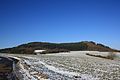 The Hochsimmer from the south
 -
 The East Top from the south
 -
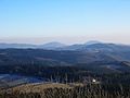 The Hochsimmer (right), seen from the Hohe Acht
 -
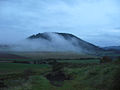 View from Hochstein


See also
References
External links
Wikimedia Commons has media related to Hochsimmer.
- Der Hochsimmer…, retrieved 28 November 2013, in Gemeinde Ettringen am Hochsimmer, at ettringen-eifel.de.